 Route Editor

| Guide | ♦ | 74 Triplogs | 0 Topics |
details | drive | permit | forecast | route |
stats |
photos | triplogs | topics | location |
| 343 | 74 | 0 |
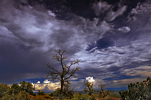
Better than Mesa! by joebartels   On this cool June Friday morning, the Doe Mountain Trail was rather busy. Doe Mountain is a small 400-foot high mesa that sits between the Cockscomb and Bear Mountain. Most of Sedona's popular trails follow a creek or canyon. This is a moderately easy trek up to a platform of views. A morning start takes advantage of the shade going up. On this cool June Friday morning, the Doe Mountain Trail was rather busy. Doe Mountain is a small 400-foot high mesa that sits between the Cockscomb and Bear Mountain. Most of Sedona's popular trails follow a creek or canyon. This is a moderately easy trek up to a platform of views. A morning start takes advantage of the shade going up.From the trailhead, get on the trail. Within in a couple minutes you cross the Aerie Trail. Then long easy switchbacks take you to the top in a flash. Once on top, I recommend taking a good look around before going anywhere. There is no official trail up here. Trails basically crisscross the mesa top forking off nearly every ten yards. Cairns scattered over the entire area offer little help for direction. Your options for adventure are plentiful. You could just work your way to the side of choice, likely looking back over Sedona. Most seem to follow the edge all the way around. Personally, I crisscrossed, circled, and spent lots of time just exploring. Most folks come up for the views in the distance. I enjoyed the sheer drop-offs along the edge more than anything.
All in all, this was a good Sedona adventure. This would be a good trail for tourists and vacationers as it is rather easy. I think I would have enjoyed the hike more if the locust weren't so annoying. In the middle of the mesa top, huge cracks ripped through the earth due to the drought. Since this was such an easy trail I explored Rarick Canyon on the way home and that was a blast. The distance given for this hike includes a mile of roaming on top. It could be more or less depending on your adventure. Camping According to the 2018 FS map camping is not allowed on any portion of this trail.
Coconino FS Details This trail not only provides a big dividend of scenery for a moderate outlay of exertion but it is easily accessible as well. From the ample parking lot at its trailhead, the Doe Mountain Trail switchbacks directly up the north side of this low, flat-topped Mesa. As you climb, you'll want to take time out to enjoy the excellent views of the surrounding countryside. A layer of erosion resistant cap rock has given Doe Mountain its classic mesa shape and provides hikers with a great platform from which enjoy the panoramic view. From this 400 foot high perspective, you can see a number of the Sedona Red Rocks Country's more prominent landmarks . You'll see Bear, Maroon and Wilson mountains, Loy, Boynton and Secret canyons, Chimney Rock, and the Cockscomb to name a few. Sedona is visible to the east and off to the south, Munds Mountain and Sycamore Pass mark the location of Sycamore Canyon and the Verde Valley. Check out the Official Route and Triplogs. Leave No Trace and +Add a Triplog after your hike to support this local community. | ||||||||||||||||||||||||||||||||||||||||||||||||||||||||||||||||||||||||||||||||||||||||||||||||||||||||||||||||||||||||||||||||||||||||||||||||||||||||||||||||||||||||||||||||||||||||||||||


