 Route Editor

| Guide | ♦ | 18 Triplogs | 1 Topic |
details | drive | no permit | forecast | route |
stats |
photos | triplogs | topic | location |
| 70 | 18 | 1 |
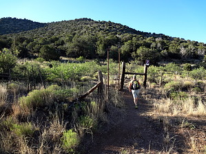
Explore! by Ksorensen   2019 Warning 2019 WarningAfter a few miles, route finding is required to connect with Bell Trail. The tread requires constant attention. The route requires a map, GPS, or cairn navigation. 2004 Hike This is a good hike to do if you've already hiked Bell Trail #13 and like the area. Nearly all of the elevation gain in this hike is in the first half mile as the trail climbs the mesa at a very steep angle. The trail is very steep until it reaches a somewhat narrow ridge that leads more gently to a second climb up to the mesa proper.
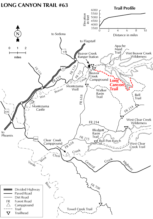
The views from the top of the mesa are not quite as awe-inspiring as the views from Packard Mesa, but they're outstanding just the same. Once you've reached the top of the mesa, the hike is pretty much flat. With a good map and an eye on the landmarks, it would be somewhat tricky to get lost on this mesa, so there is an opportunity to go off-trail and explore. The vegetation on top of the mesa is the juniper and stunted pinon pine typical of the area. The trail is easy to follow, but other trails do splinter off from it, so it's probably best to bring a map just in case. The trail follows closely enough to the edge of the canyon that you can trek a short distance over to the edge for a view at nearly any point on this hike. We wandered along at a leisurely pace, alternately hiking and then stopping to look for more pottery shards and habitation sites. We had planned to hike this trail until its convergence with the Bell Trail and then come back around on the Bell Trail as a loop. However, we got a late start and took a lot of extra time exploring and wasting time, so we only made it about five miles down the trail and were forced to return the way we came. I think it would be possible to make a loop out of this trail and the Bell Trail, but you'd probably need to get a very early start. Coconino FS Details This trail starts upstream of the Beaver Creek Campground and switchbacks up to the top of the mesa providing glimpses of the Verde Valley and the red rock country of Sedona on the way. Once on the mesa, the trail levels out and affords a panoramic view of the surrounding country, including the San Francisco Peaks to the north. The trail trends in a southeasterly direction and climbs again to the top of the Mogollon rim. Once on the rim, the trail may be indistinct and thus hard to follow. Look for the rock cairns that mark the route. The trail passes by Long Canyon Tank, which provides the only source of water on the trail. Vegetation removal on the rim has left forested "fingers" that provide important cover for wildlife. Watch for elk, antelope, and deer in these areas of mixed forest and grassland. The trail crossed the road that runs to the east of Long Canyon Tank and enters the forested area along the edge of Long Canyon. The prehistoric Sinagua culture utilized this area, and artifacts and habitation sites may be found. Remember that Federal law prohibits the removal of artifacts and the damaging of archeological sites. Leave any artifacts found for the enjoyment of others and take only photographs. The trail continues southeasterly following the canyon and crosses the north and south forks of Long Canyon before heading north to the junction with the Bell Trail #13. Be sure to bring a topographic map of the area, compass, and plenty of water when hiking this trail.
Check out the Official Route and Triplogs. Leave No Trace and +Add a Triplog after your hike to support this local community. One-Way Notice This hike is listed as One-Way. When hiking several trails on a single "hike", log it with a generic name that describes the hike. Then link the trails traveled, check out the example. | |||||||||||||||||||||||||||||||||||||||||||||||||||||||||||||||||||||||||||||||||||||||||||||||||||||||||||||||||||||||||||||||||||||||||||||||||||||||||||||||||||||||||||||||||||||||||||||||||


