Route Editor

| Guide | ♦ | 39 Triplogs | 0 Topics |
details | drive | permit | forecast | 🔥 route |
stats |
photos | triplogs | topics | location |
| 390 | 39 | 0 |
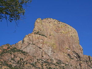
spiritual by brianb   Western Approach Western ApproachBaboquivari Peak is one of the most prominent and distinct peaks in southeastern Arizona. Sticking up 1000 feet or more above the surrounding mountains, with its characteristic pyramid-shaped peak, it beckons the curious. On a clear day, it can be seen from over 100 miles away. However, it is not visited much due to its relative isolation and the time/difficulty getting there. But it is a massive and towering, solid bare rock peak surrounded by beautiful, shorter mountains. It is worth the trip to see it up close. It is also a lovely hike. It is perhaps better known as a climbing destination than a hiking one since its summit can only be reached via technical climbing skills (i.e., ropes, etc.). However, you can easily hike the trail to the rocky peak base and even scramble, way or so up the peak itself without climbing gear. In either case, it's a wonderful destination not to be missed. Your first view of Baboquivari up close will leave you in awe. That alone is worth the trip.
From the rear of the parking lot/campsite, look for the trailhead, marked with a little wooden sign. Being on Indian land (Tohono O'odham Nation), it is not (to my knowledge) a USFS trail, but it is the only trail out there, and it heads right for the base of Baboquivari Peak. The trail begins in a typical Sonoran environment (about 2800 feet), but with more reddish soil, rocks, and more oaks than you'd usually see at this elevation. The view is incredible from the word "go." The trail is, in most places, well maintained and easy to follow. Within the 1st mile or so, the trail crosses a wash. Look for the sign pointing the way to the trail. This is probably the only place you might lose the trail. The soil and rocks in this area are more reddish, making for a pretty sight around sunset. You will also see lots of beautiful, purple-colored prickly pear cacti (different species?) and little, red pincushion-type cacti (species?) Baboquivari Peak itself will fade into and back out of view (mostly out of sight) throughout the hike up, especially the first 1/2 of the trip. The trail begins relatively level as you wind your way around the lower peaks, then becomes steadily steeper, getting steeper as you get higher. I would rate the grade of the ascent overall as "medium-steep." If you go all the way to the base of the peak, you cover about 4000 vertical feet in four miles or so. Plan on a 6-8 hour hike, depending on how far up you go. It isn't easy to arrive at an actual distance for this trip since I have not found any maps with this trail on it. It is not (to my knowledge) a USFS trail. I would put the trek from the campsite to the base of the peak at around four miles. The elevation is also a guestimate, the top of the peak is about 7800 feet, and the base is approximately 2800 feet - and I'd guess that the base of the peak where the trail ends is about 1000 feet below the very top, making it about a 4000-foot vertical trip. After a mile and a half or so, you will reach several areas where you can finally see the mountains to the east of Baboquivari (which is quite the view) and the valley below and to the south. These areas are beautiful, with a wide variety of trees and plants and patches of dry grassland. You might also see a deer or two in this area. The peak itself is still out of view at this point. Further on up the trail, you'll begin heading steeply downhill, then back uphill. Shortly you will be rewarded with your first good look at the peak since the beginning of the trip. What a sight!! It can take your breath away. There's nothing quite like it in this neck of the woods. The trail will continue to switchback, with the peak coming into and fading from view. Along this point, the oaks will begin to give way to pines, and you'll even travel through a canopy of pines in several spots. The wind starts to pick up as you travel across a more exposed part of the mountain. The trail begins to thin somewhat here but is still relatively easy to follow. The trail becomes very steep in parts along here, as well. From here, you can follow the trail to its end. Which drops you off unceremoniously at the base of the rocky peak itself (at the intersection of what I believe are called Lion's Ledge and The Great Ramp, which are self-evident), or you might want to pick a spot near the top with a nice view of the peak and the surrounding vistas - to rest, eat lunch and return. However, you can reach a point roughly halfway up the rocky peak, which offers fantastic views to the north, west, and south. Reaching this point will mean leaving the trail, but you should have no trouble finding your way up and back. There is really only one way up and back down. Caution: going beyond the end of the trail and up the peak involves a little scrambling on some fairly steep, sheer rock faces. I did not find this part too challenging or dangerous, but if you're not familiar with or comfortable with this kind of terrain, you should think twice and use caution. I'm not sure I'd drag my kids up here, in other words. That said, you can reach several points, with only a little scrambling or minor climbing, which offer some incredible views of the surrounding territory some 4000 feet below. There are a few "mini-peaks" you can reasonably easily reach, which provide fantastic views. Much beyond these, you need technical climbing skills and climbing gear. A few more paces up the mountain should quickly convince you of that. It is cool, however, to get a good look around while you're up there. It's definitely worth the extra time and effort. Just know when to say "when" and don't try to keep going up. You can't, not without climbing gear and experience. Baboquivari is a fabulous destination, but it is also a sacred place to the Tohono O'odham. Therefore, please treat this sacred place with a little extra respect, as most of us will be visitors to the Tohono O'odham Nation. Pro sbkelly beta for those interested in climbing the ladder pitch.... The full pitch (from chains by the tree at the top of the pitch to the bottom) is just about 100', so a 60m rope, two quickdraws (for the leader), plus your standard harness/helmet/carabiner/ATC should do the trick on gear. If you've got a bunch of strong and confident free-climbers and down climbers, you could get away with a shorter rope by only protecting and rappelling the first 30', but the safer route is the full 60m. Check out the Official Route and Triplogs. Note This is a difficult hike. Arrive fit and prepared or this could get ugly. Leave No Trace and +Add a Triplog after your hike to support this local community. | ||||||||||||||||||||||||||||||||||||||||||||||||||||||||||||||||||||||||||||||||||||||||||||||||||||||||