 Route Editor

| Guide | ♦ | 19 Triplogs | 1 Topic |
details | drive | permit | forecast | 🔥 route |
stats |
photos | triplogs | topic | location |
| 143 | 19 | 1 |
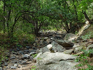
Sedona solitude! by joebartels   Dry Creek takes the honor of naming a significant street in Sedona. Trail books usually mention this trail. Ironically the best-kept secret in Sedona for beautiful solitude is Dry Creek Trail #52. No real destination or well know landmarks may be the reason for the lack of crowds. Lucky you! Dry Creek takes the honor of naming a significant street in Sedona. Trail books usually mention this trail. Ironically the best-kept secret in Sedona for beautiful solitude is Dry Creek Trail #52. No real destination or well know landmarks may be the reason for the lack of crowds. Lucky you!The trail cuts in and out of the creek. Just after a half-mile (0.7mi), the canyon forks. Bear Sign Creek/Trail is to the left, and Dry Creek is the right fork. Continue on the right. Beautiful sandstone ledges run along the sides and make the trail in sections. Terraced sandstone ledges fill the creek wall to wall in areas putting you in awe. Low canyon walls are steep and close to you. Cairns are everywhere, but who needs cairns in a narrow corridor. This canyon is too narrow to get lost. Just keep going until the going gets tough. Take lunch and enjoy a break on the beautiful red rock. Take a friend and enjoy a memorable conversation. No big perks. Only pure beauty and silence on this Arizona gem.
Coconino FS Details This trail is an infrequently used trail that has a true remote feel. It is shady and can be hiked in summer. Begin at the Dry Creek trailhead west of the parking area across a wash. The trail immediately enters Wilderness Area and turns right as it meets Dry Creek and follows along this usually dry streambed. At .75 miles, there is a junction with Bear Sign Trail. Dry Creek Trail continues ahead to the right. The trail climbs gradually parallel to the drainage with views of the red rock walls of this rugged canyon. Later, the trail narrows and becomes less distinct, but is never far from the dry streambed. At 2.5 miles, the trail crosses a large wash and becomes much harder to follow. If you do not have good route finding skills, this junction is a good place to turn back. If you decide to continue, cross the wash, turn to the right, and follow the wash to the north for approximately one more mile, coming close up under the Mogollon Rim in a dense stand of ponderosa pine. The trail ends here. Return by the same route for a 6 mile hike. Check out the Official Route and Triplogs. Leave No Trace and +Add a Triplog after your hike to support this local community. One-Way Notice This hike is listed as One-Way. When hiking several trails on a single "hike", log it with a generic name that describes the hike. Then link the trails traveled, check out the example. | |||||||||||||||||||||||||||||||||||||||||||||||||||||||||||||||||||||||||||||||||||||||||||||||||||||||||||||||||||||||||||||||||||||||||||||||||||||||||||||||||||||||||||||||||||||||||||||||||||||||||||||


