 Route Editor

| Guide | ♦ | 36 Triplogs | 3 Topics |
details | drive | permit | forecast | 🔥 route |
stats |
photos | triplogs | topics | location |
| 248 | 36 | 3 |
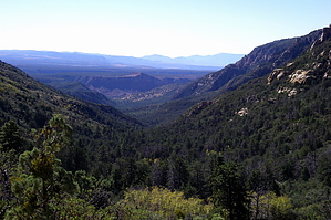
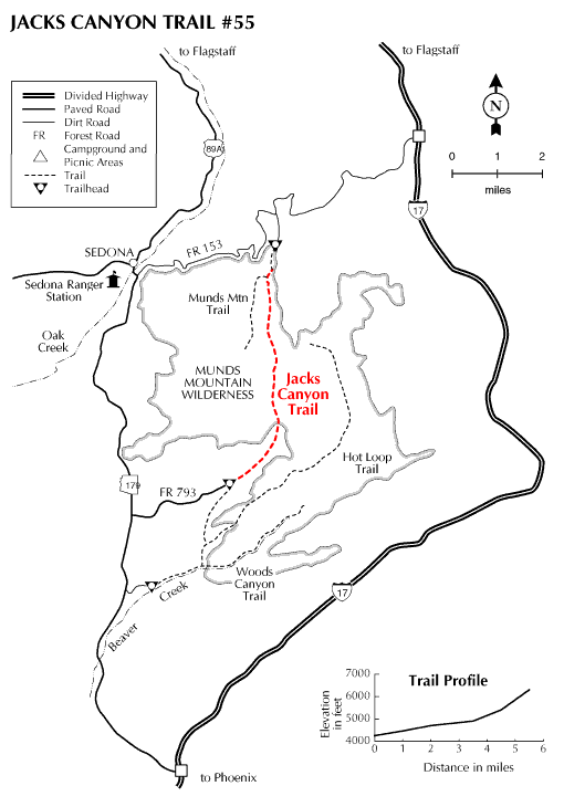
Several sucky miles then Wham Bam by HAZ_Hikebot   You'll want to hike this trail to the end and then some to gain access to the unique views it offers. Jacks Canyon Trail leads up the bottom of a rocky desert gorge where the vegetation is mostly high chaparral. Watch for desert cottontails and black-tailed jackrabbits scurrying through the thorny underbrush. Most likely you'll see some top-knotted Gambels quail, too, and hear them crowing from their hiding places as you pass by. Extensive stands of Arizona cypress carpet the canyon floor along with catclaw acacia, false palo verde, and banana yucca. You'll want to hike this trail to the end and then some to gain access to the unique views it offers. Jacks Canyon Trail leads up the bottom of a rocky desert gorge where the vegetation is mostly high chaparral. Watch for desert cottontails and black-tailed jackrabbits scurrying through the thorny underbrush. Most likely you'll see some top-knotted Gambels quail, too, and hear them crowing from their hiding places as you pass by. Extensive stands of Arizona cypress carpet the canyon floor along with catclaw acacia, false palo verde, and banana yucca.The trail starts by skirting the boundary of an outlying subdivision. It then follows an old jeep trail to Jacks Canyon Tank where it drops into the drainage bottom and proceeds along its moderate climb by crisscrossing the dry streambed. At the upper end of the canyon, the trail leaves the streambed to switchback to a high saddle connecting the Mogollon Rim and Munds Mountain. The views are good here, but they're even better a short, steep climb up the Munds Mountain Trail #77. From the top of Munds Mountain, the panorama of the Red Rocks Country is as complete as it gets, including parts of Oak Creek Canyon, all of the major rock formations around Sedona, and even the San Francisco Peaks in the distance.
According to the 2018 FS map camping is not allowed on the lower portion of this trail but is allowed up in Munds Mountain Wilderness. The wilderness boundary begins 3 miles up the trail.
Check out the Official Route and Triplogs. Leave No Trace and +Add a Triplog after your hike to support this local community. One-Way Notice This hike is listed as One-Way. When hiking several trails on a single "hike", log it with a generic name that describes the hike. Then link the trails traveled, check out the example. | |||||||||||||||||||||||||||||||||||||||||||||||||||||||||||||||||||||||||||||||||||||||||||||||||||||||||||||||||||||||||||||||||||||||||||||||||||||||||||||||||||||||||||||||||||||||||||||||||||||||||||||||||


