 Route Editor

| Guide | ♦ | 43 Triplogs | 2 Topics |
details | drive | permit | forecast | route |
stats |
photos | triplogs | topics | location |
| 357 | 43 | 2 |
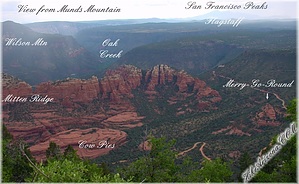
Visual Encounter by joebartels  The views from Munds Mountain will never leave your mind. Stunning overhead views include Bear Wallow Canyon among countless landmarks. A mass profile of Wilson Mountain couldn't be more perfect. Top it off with a jaw-dropping view of Oak Creek Canyon snaking its way up to Flagstaff in front of the San Francisco Peaks! The views from Munds Mountain will never leave your mind. Stunning overhead views include Bear Wallow Canyon among countless landmarks. A mass profile of Wilson Mountain couldn't be more perfect. Top it off with a jaw-dropping view of Oak Creek Canyon snaking its way up to Flagstaff in front of the San Francisco Peaks!Three trailheads access Munds Mountain. I speculate most would come up on the Schnebly Hill Trail #158 accessed off Schnebly Hill Road. The long approach is up Jack's Canyon. The approach given here is the easiest if you have a four-wheel-drive vehicle.
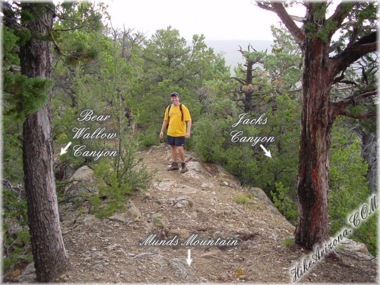
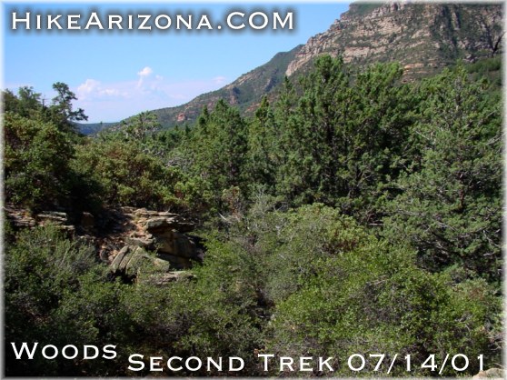
Getting to the trailhead is an adventure in itself. (see directions below) Go through the barbed wire gate and hook it back together behind you. It's unlikely you'll be able to spot the trail so read carefully, just kidding it's a breeze. Jacks Canyon is close to the west with Munds Mountain rising above. There's a saddle over to Munds Mountain. Just head right for it. It's about a 20-25 degree angle out from the fence line to the west. Soon you will find yourself on an overgrown trail. Follow this across the saddle. First, you will see the backside of Schnebly Hill Trail #158 sign as it comes in from the northeast. Crossing the saddle you have a great view down Jack's Canyon to the south. To the north and northwest are slightly hidden views of the red rock of Bear Wallow Canyon. Next, you will see the collection of signs for Munds Trail #77 and Jack's Canyon Trail #55-S. Jack's Canyon Trail heads straight down on loose footing. Head up the Munds Trail straight ahead. It's a hearty ascent. The good news is it's short so I believe most could make it up without trouble. On the way up there's a short ridge section, best described as totally cool. Continue... Near the top are some of the finest oak leaves around. The leaves were perfect (healthy green, disease-free & not a single insect nibble). On top of Munds Mtn is a nice open field. A few twisted junipers accent the landscape. The trail goes for a while then fizzles out. The ground is a maze of dried-up crevasses you'd expect to see in southwestern Arizona. Follow the official route or just hang a right and head for the edge. As stated above, the views are awesome. 2018 Update The trail across the mountain is easier to follow now. It's easy to travel and worth the effort to check out other views or Lee Mountain. The only issue is game trails fork off all over the place. Utilize the Official Route for peace of mind 2001 HAZ Story I wanted to explore around on top some more but it wasn't in the cards on this trip. Munds Mountain wasn't even part of our plans for the day. Originally we planned on hiking down Jack's Canyon just about two miles. Then we planned on taking a steep ravine up the east ridge separating Woods Canyon at about the midpoint. We had a precisely loaded trail in the GPS to cut right over to the Indian ruins in Woods Canyon. The ridge (which extends down into Horse Mesa) has a steep ravine on the Woods Canyon side and an even steeper ravine on the Jack's Canyon side. All went according to plan with one exception. The prickly Live Oak shrubs among others coupled with THICK Manzanita and plenty of the dead variety took its toll. My heart was set but I could tell my partner Tony wasn't happy. Okay, backtrack here a second. All didn't go well. I first misjudged the ravine and we were off track by a hundred yards. So we had to bushwhack more of the mean brush than necessary. After a half-hour, we ended up only a third of the way. We headed back down. I could see Tony get excited as we would now have time to ascend Munds Mountain on the way back. We headed back up Jack's Canyon. For the record, don't waste your time on this canyon. It's not that it's terrible, there's just much better hiking around the area. There is a nice level camp spot along the way and lots of shade too. Back up on the saddle, I was pretty sure a monsoon was rolling in. I didn't want to disappoint Tony so I kept on going up without stopping. I have to admit it was more than I expected. Originally I was saying, I've seen all this stuff man it's no big deal. Then I stepped out on the edge of the rim and my mind changed quickly. Within minutes it began to rain. I shot photos rapidly in sequence, basically hoping to capture a shot. We headed back down. The thunder paused out of rhythm. Then came the downpour. We could hear the truck alarm across the canyon so it wasn't hard to figure the way back. All was good except the rain muddied up the road. It was a fun ride home, to put it mildly. Gate Policy: If a gate is closed upon arrival, leave it closed after you go through. If it is open, leave it open. Leaving a closed gate open may put cattle in danger. Closing an open gate may cut them off from water. Please be respectful, leave gates as found. The exception is signage on the gate directing you otherwise.
Check out the Official Route and Triplogs. Leave No Trace and +Add a Triplog after your hike to support this local community. | ||||||||||||||||||||||||||||||||||||||||||||||||||||||||||||||||||||||||||||||||||||||||||||||||||||||||||||||||||||||||||||||||||||||||||||||||||||||||||||||||||||||||||||||||||||||||||||||||||||


