Expansive views, lots of connecting trails, and access to the western portion of the Wilderness of Rock with its immense boulders and picturesque formations characterize this high country trail. The Mt. Lemmon Trail starts out near the summit of the 9,157-foot peak for which it is named, at a parking area about a mile past Mt. Lemmon Ski Valley near the end of Observatory Road. After following an access road along a buried powerline, it strikes off on a more backcountry course down one of the most prominent ridges that fan out from the mountaintop. Views are big here, encompassing the Wilderness of Rock to the southeast, Romero Canyon to the west and north, and most dramatic of all, Pusch Ridge to the west, stair-stepping its sawtooth course toward Tucson.
The route Mt. Lemmon Trail follows through this rugged, mountainous country is steep and rocky in a number of places. Most notable of those difficult stretches are the series of switchbacks where the trail drops off the high ridge of the Catalinas toward the Wilderness of Rock, and the section between the Wilderness of Rock Trail #44 and West Fork Trail #24 junctions where trail gradients are as steep as they get in the Santa Catalinas.
The Mt. Lemmon Trail provides access to a number of other trails in the Pusch Ridge Wilderness including Sutherland #6, Lemmon Rock Lookout #12, Wilderness of Rock #44, Romero #8, and West Fork #24 trails. Many who hike this trail leave a second vehicle at one of these other trailheads and use the Mt. Lemmon Trail as part of a long day trip or a segment of a multi-day backpack. Whatever option you choose, chances are good that you'll be back to try one of the others.
Dogs are permitted on all but about the bottom tenth to quarter-mile to Romero Pass.
Attractions:
Fabulous views of Pusch Ridge
Overlooks of Wilderness of Rock
Access to Sabino Basin
Mountaintop to desert diversity
Arizona Trail segment
When hiking several trails on a single "hike", log it with a generic name that describes the hike. Then link the trails traveled, check out the example.
WARNING! Hiking and outdoor related sports can be dangerous. Be responsible and prepare for the trip. Study the area you are entering and plan accordingly. Dress for the current and unexpected weather changes. Take plenty of water. Never go alone. Make an itinerary with your plan(s), route(s), destination(s) and expected return time. Give your itinerary to trusted family and/or friends.
Four specific day-use areas require a Coronado Recreational Pass or a National Pass/America the Beautiful Pass.
1) Sabino Canyon - located on the Santa Catalina Ranger District (520)749-8700
2) Madera Canyon - located on the Nogales Ranger District (520)281-2296
3) Cave Creek - located on the Douglas Ranger District (520)364-3468
4) Mt. Lemmon at 11 day-use sites.
2025Catalina State Park
Per vehicle (1 person): $10.00
Per vehicle (2-4 people): $20.00
Individual/bicycle: $5.00
Coronado Forest MVUMs are rarely necessary to review unless mentioned in the description or directions Coronado Motor Vehicle Use Maps (MVUMs)
Directions
Road
Paved - Car Okay
To hike Take the Catalina Highway off Tanque Verde Road in Tucson. Drive 4.2 miles to the Forest boundary and continue 28 miles, past Mt. Lemmon Ski Valley, to the power substation on Radio Ridge. Hike west on the trail to a dirt road. Hike down the road to the trail junction.
The Catalina Highway is paved and suitable for passenger cars. Observatory Road is an all-weather graveled road. Both roads may be snow-covered in winter, when chains or 4-wheel drive may be required. Observatory Road beyond Mt. Lemmon Ski Valley is not maintained for public use during the winter. It is closed when snow-covered or icy.
 Route Editor

 Expansive views, lots of connecting trails, and access to the western portion of the Wilderness of Rock with its immense boulders and picturesque formations characterize this high country trail. The Mt. Lemmon Trail starts out near the summit of the 9,157-foot peak for which it is named, at a parking area about a mile past Mt. Lemmon Ski Valley near the end of Observatory Road. After following an access road along a buried powerline, it strikes off on a more backcountry course down one of the most prominent ridges that fan out from the mountaintop. Views are big here, encompassing the Wilderness of Rock to the southeast, Romero Canyon to the west and north, and most dramatic of all, Pusch Ridge to the west, stair-stepping its sawtooth course toward Tucson.
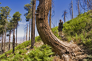


