 Route Editor

| Guide | ♦ | 47 Triplogs | 0 Topics |
details | drive | permit | forecast | 🔥 route |
stats |
photos | triplogs | topics | location |
| 254 | 47 | 0 |
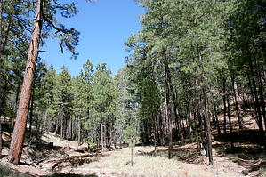
Downhill but steep by Wildcat04   The Box Camp Trail provides a "ponderosa to saguaro" hike in the Santa Catalina Mountains that will take the hiker through every life zone of the Sonoran Desert. Created in 1897, it was once the most popular pack route into the high country for an escape from the summer heat in the Tucson basin. The Box Camp Trail provides a "ponderosa to saguaro" hike in the Santa Catalina Mountains that will take the hiker through every life zone of the Sonoran Desert. Created in 1897, it was once the most popular pack route into the high country for an escape from the summer heat in the Tucson basin.Because of its steep and rocky terrain, the Box Camp Trail is most often hiked downhill, beginning at the trailhead (8,050 feet) next to the Catalina Highway. The first two miles of the trail are by far the most pleasant of the entire hike; a gentle descent combined with thick, shady forest and a carpet of pine needles under your feet offer the perfect relief from Tucson's typically hot and dry climate. Some bear sign may be seen in the area, as well as the occasional squirrel. At times, the trail follows (and sometimes crosses) a drainage leading down into Sabino Canyon, which, in the rainy seasons, may contain water.
Slightly less than five miles from the trailhead, Apache Spring appears. This spring usually has some amount of water flowing through it, but don't count on it as a water source. The vegetation has now changed to juniper and occasional oak, with some cacti thrown in for variation. The remaining 2.3 miles down to Sabino Basin traverse through saguaro and dry grassland. The last half mile may be difficult to follow; if you get lost, just bushwhack down to the basin, which is a large area filled with oak trees and bushes next to a creek bed. The basin is shady and cool, giving the hiker a wonderful rest spot. From Sabino Basin, you have a few options. After crossing the creek bed, the Box Camp Trail comes to an end and intersects with three different trails: The West Fork Trail, which will take you to Hutch's Pool; The East Fork Trail, which connects with the Palisade Trail in less than a mile; and Sabino Canyon Trail #23, which will lead you back to the end of the Sabino Canyon Recreation Area. From there, you can walk down the road for 4 miles back to the visitor's center, or ride the tram back for a fee. Overall, the Box Camp Trail is an exciting downhill hike that takes the better part of a day. Expect to spend about 3-4 hours hiking down to Sabino Basin (7.1 miles), and another 1 to 1 1/2 hours if you hike back to the Sabino Canyon Recreation Area (9.6 miles).
Coronado FS Details Box Camp Trail provides some of the most dramatic views of any trail in the Santa Catalinas. It also challenges the wilderness traveler with some of the steepest and rockiest. As you might expect, the most rugged sections also offer the best views. This trail extends between the Catalina Highway in the vicinity of Spencer Campground and the East Fork Trail in the Sabino Basin. During the summer, most people hike this trail from the top down. During the winter, use increases on the lower end of the trail. 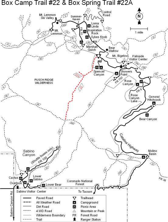 Starting from the top, the trail follows a course through magnificent stands of large ponderosa pines. If you would like to take an interesting side trip, Box Spring Trail #224A leads 0.9 mile to a perennial spring. Below the turnoff to the spring this trail begins its steep descent into Sabino Basin. This section is steep and brushy. In some places it can be hard to find. It is maintained infrequently, so if you do come, expect to work hard for the vistas that you will find here. They include views of Sabino Basin, Palisade Canyon and the sprawling city of Tucson in the distance. And in the Fall, aspen leaves splash the mountain slopes with gold. Before the Catalina Highway was constructed, this trail was the quickest access route to the Soldier Camp high on the mountain's pine-clad slopes. Attractions: Great views Tall trees Forest to desert diversity Challenging trail Check out the Official Route and Triplogs. Note This is a more difficult hike. It would be unwise to attempt this without prior experience hiking. Leave No Trace and +Add a Triplog after your hike to support this local community. One-Way Notice This hike is listed as One-Way. When hiking several trails on a single "hike", log it with a generic name that describes the hike. Then link the trails traveled, check out the example. | ||||||||||||||||||||||||||||||||||||||||||||||||||||||||||||||||||||||||||||||||||||||||||||||||||||||||||||||||||


