Route Editor

| Guide | ♦ | 81 Triplogs | 3 Topics |
details | drive | permit | forecast | 🔥 route |
stats |
photos | triplogs | topics | location |
| 391 | 81 | 3 |
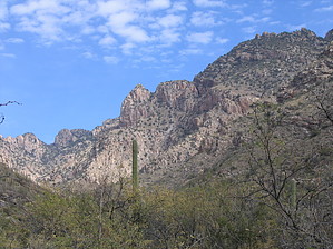
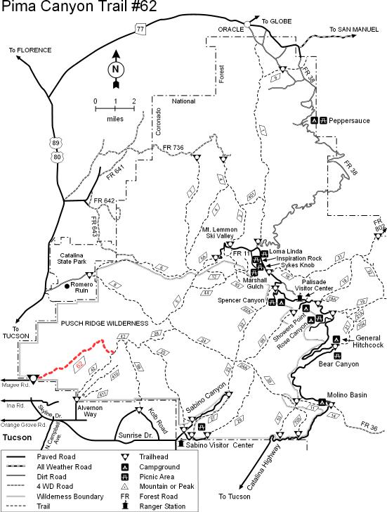
Diverse and challenging by Wildcat04  The last stretch of the Pima Canyon Trail is far and away the steepest and most brutal of footpaths in the Santa Catalina Mountains' front range. Although the first 3.2 miles are nothing more than a walk for most, the final 4 miles to Mount Kimball are unrelenting and unforgiving. The last stretch of the Pima Canyon Trail is far and away the steepest and most brutal of footpaths in the Santa Catalina Mountains' front range. Although the first 3.2 miles are nothing more than a walk for most, the final 4 miles to Mount Kimball are unrelenting and unforgiving.Beginning in the desert scrub at the base of the Catalinas, the Pima Canyon Trail leaves the parking lot (2,900 feet) and travels gently uphill for a short distance. Saguaros are abundant on the hillside, and in warmer months, may have flowers in bloom. Turning back to the southwest reveals gorgeous views of West Tucson, providing an excellent opportunity for photos. Shortly after that, the trail drops down into Pima Canyon and winds across a drainage numerous times as the vegetation occasionally transitions into a riparian (streamside) habitat. After three miles of hiking, you will arrive at the Pima Canyon Dam (3,700 feet), where two small, bowl-shaped depressions in a large slab of rock signify the imprints of the Hohokam Indians, whose women used the rock to grind mesquite beans over 1,000 years ago.
As always, summitting Mount Kimball is well worth it. The tall pines are a welcome sight after a long, exhausting, 7.1-mile hike. Kimball's actual high point is not the most spectacular, though; walk as far as possible on the trail until it reaches a rock outcropping overlooking the "other side" of the Catalinas. The sight of looking down onto Interstate 10 and Biosphere 2, and the views of Mount Lemmon and Cathedral Rock, are sure to be among the most memorable impressions of any trail you've ever hiked in the state of Arizona. To return to the trailhead, just hike back the way you came. On a personal note, this trail is a favorite of mine for three reasons: 1) It provides a formidable physical challenge; 2) One can cross several different life zones in a relatively short amount of time; and 3) It's another way to get up to Mount Kimball, which is never disappointing in regards to scenery. I would recommend hiking this trail during the spring or autumn months so that one will avoid heatstroke down low and lighting strikes up high during the summertime, and icy or snowy conditions during the wintertime. I have been on top of Mount Kimball in all conditions, and believe you me, it is very subject to harsh conditions given its exposure to the elements of nature.
Coronado FS Details Though the stream in Pima Canyon is dry for most of the year, it supports a desert riparian habitat located conveniently close to the Tucson metropolitan area. Unfortunately, that accessibility has resulted in significant overuse of this beautiful and fragile area, especially during the winter, its season of highest use. From the trailhead, located among suburban ranchos, the trail ascends a V-shaped notch carved along the south face of Pusch Ridge. Views down the canyon get better as you climb, encompassing the city of Tucson as well as distant mountains and valleys. The riparian area on the floor of the canyon provides excellent bird watching for a wide variety of resident and migratory species that make use of this most productive of all desert habitat types. Other desert creatures you may encounter in this area include javelina and jackrabbits, but the real viewing prize of Pima Canyon and the entire Pusch Ridge area are the desert bighorn sheep that maintain a surefooted existence here among rocky crags and rugged canyons. Beyond Pima Spring, the trail becomes steeper and harder to follow as it continues to climb to the upper slopes of Mt. Kimball. Incentives for persevering here are good views of Window Rock and Cathedral Rock. Trail #62 ends at its junction with the Finger Rock Trail #42. Attractions: Riparian forest Canyon hike Craggy peaks Wildlife Tucson views Check out the Official Route and Triplogs. Note This is a difficult hike. It would be insane to attempt this entire hike without prior experience hiking. Leave No Trace and +Add a Triplog after your hike to support this local community. | |||||||||||||||||||||||||||||||||||||||||||||||||||||||||||||||||||||||||||||||||||||||||||||||||||||||||||||||||||||||||||||||||||||||||||||||||||||||||||||||||||||||||||||||||||||||||||||||||||||||||||||||||||||||