Route Editor

| Guide | ♦ | 19 Triplogs | 0 Topics |
details | drive | no permit | forecast | route |
stats |
photos | triplogs | topics | location |
| 74 | 19 | 0 |
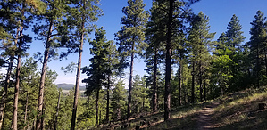
  Overview OverviewThe trail provides visitors to Dogtown Lake with an interesting, scenic day hike to the top of Davenport Hill and back. The higher elevation of the hill (7805 feet) and the northern exposure of the trail provide hikers with a cool climatic change and also a change in vegetation from ponderosa pine to Douglas fir, white fir and oak near the summit. Hike The trail follows Dogtown Wash about 0.3 miles and then climbs to a flat, where it follows an old logging road before turning north toward Davenport Hill. The trail ascends the hill at a gradual 8% grade to the top. Although the trail ascends 745 feet, flowing switchbacks take most of the sweat and toil out of the climb. The first mile is an effortless stroll through woodlands of Gambel oak, ponderosa pine, and sunny clearings. The uphill trudge begins where the trail crosses unsigned FR200 and move onto the first of several edge-hugging switchbacks.
Follow the same trail back to the start. From the trail, you can enjoy scenic views of Dogtown Lake and the country around Williams. Source The excellent summary above is from the Kaibab FS. Whoever wrote it nailed it, which is rare for the FS. Minor corrections by the wonder mutt (co-author). Gate Policy: If a gate is closed upon arrival, leave it closed after you go through. If it is open, leave it open. Leaving a closed gate open may put cattle in danger. Closing an open gate may cut them off from water. Please be respectful, leave gates as found. The exception is signage on the gate directing you otherwise. Check out the Official Route and Triplogs. Leave No Trace and +Add a Triplog after your hike to support this local community. | ||||||||||||||||||||||||||||||||||||||||||||||||||||||||||||||||||||||||||||||||||||||||||||||||||||||||||||||||||||||||||||||||||||||||||||||||||||||||||||||||||||||||||||||||||