 Route Editor

| Guide | ♦ | 52 Triplogs | 0 Topics |
details | drive | permit | forecast | 🔥 route |
stats |
photos | triplogs | topics | location |
| 510 | 52 | 0 |
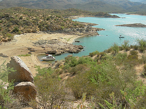
Beachin Views! by HAZ_Hikebot   The south end of the trail begins near the northern edge of the Rattlesnake Cove Recreation Site. The trail roughly parallels the shoreline of Bartlett Reservoir, providing access to the shore, crossing washes and small ridges, and running along hillslopes. From Rattlesnake Cove Trailhead to SB Cove is 3.8 mi. A 1.2 mi. loop-trail intersects the main trail at two locations: about 0.5 mi. south of SB Cove and again at 0.8 mi. south of SB Cove. The loop trail provides access to other areas near the edge of the reservoir. The south end of the trail begins near the northern edge of the Rattlesnake Cove Recreation Site. The trail roughly parallels the shoreline of Bartlett Reservoir, providing access to the shore, crossing washes and small ridges, and running along hillslopes. From Rattlesnake Cove Trailhead to SB Cove is 3.8 mi. A 1.2 mi. loop-trail intersects the main trail at two locations: about 0.5 mi. south of SB Cove and again at 0.8 mi. south of SB Cove. The loop trail provides access to other areas near the edge of the reservoir.ATTRACTIONS - Palo Verde Trail offers access to many coves and stretches of shoreline, providing opportunities for swimming and angling. The trail winds through rocky outcrops and crosses several ridges and hill slopes offering scenic views of Bartlett Reservoir. *This trail passes through the Arizona Upland Phase of the Sonoran Desert, featuring Saguaros, mesquite, paloverde, and ironwood trees. - Bartlett Reservoir has been popular with anglers almost since the dam was constructed in 1939. Fish species include crappie, large and smallmouth bass, channel and flathead catfish, carp, bluegill, and green sunfish. - Along with many partners, the USDA Forest Service is improving fish habitat by installing a variety of structures in strategic locations.
- Closed to motor vehicles - Carry an adequate supply of drinking water. One gallon/per person/per day is recommended during hot periods. - If you PACK IT IN, PACK IT OUT!! - Portions of the trail are rough in places and should be traveled with caution. Decomposed granite trail surface can be slippery. - Water levels fluctuate seasonally based on precipitation and irrigation demand - Do not drink untreated water. Giardia, a protozoan, is in many water impoundments and streams. RANGER DISTRICT Cave Creek Ranger Station 40202 N. Cave Creek Rd. Scottsdale, Arizona 85262 Phone (480) 595-3300 Fax (480) 595-3342 TRAILHEADS (TH) Rattlesnake Cove TH SB Cove TH TERMINI INFORMATION South end: (1840 feet elevation): at Rattlesnake Cove North end: (1820 feet elevation): at SB Cove TRAIL INFORMATION Trail use: Light Trail difficulty: Easiest Trail length: 3.8 - 4.7 miles Season of Use: All year USGS maps: Bartlett Dam, Maverick Mountain Elevation: 100 feet
Check out the Official Route and Triplogs. Leave No Trace and +Add a Triplog after your hike to support this local community. One-Way Notice This hike is listed as One-Way. When hiking several trails on a single "hike", log it with a generic name that describes the hike. Then link the trails traveled, check out the example. | |||||||||||||||||||||||||||||||||||||||||||||||||||||||||||||||||||||||||||||||||||||||||||||||||||||||||||||||||||||||||||||||||||||||||||||||||||||||||||||||||||||||||||||||||||||||||||||||||


