Route Editor

| Guide | ♦ | 26 Triplogs | 1 Topic |
details | drive | permit | forecast | route |
stats |
photos | triplogs | topic | location |
| 180 | 26 | 1 |
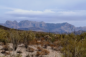
Expansive Views by desertgirl  Victoria Mine Trail is a great trail in the Organ Pipe Cactus National Monument that offers an interest into the human history of the area in a beautiful natural setting of the Sonoyta Mountains. The trail begins at the south end of the auto campground, located about 1.5 miles from the Visitor Center. The well-marked trail to Victoria Mine heads southwest through gently rolling alluvial fans called bajadas, marked by creosote bush, greasewood, cholla, graceful ocotillo and paloverde and saguaros and a few Organ Pipe Cactus stands. You will run into occasional drops into washes, where greater moisture allows for the growth of paloverde, mesquite, and abundant stands of cacti. Looking around, you can see the distant crest of Pinkley Peak to the north and of the Sierra Cubabi across the Mexican border and the Sonoyta Valley before you. On a clear day, you may be able to spy the border posts of Lukeville-Sonoyta. Victoria Mine Trail is a great trail in the Organ Pipe Cactus National Monument that offers an interest into the human history of the area in a beautiful natural setting of the Sonoyta Mountains. The trail begins at the south end of the auto campground, located about 1.5 miles from the Visitor Center. The well-marked trail to Victoria Mine heads southwest through gently rolling alluvial fans called bajadas, marked by creosote bush, greasewood, cholla, graceful ocotillo and paloverde and saguaros and a few Organ Pipe Cactus stands. You will run into occasional drops into washes, where greater moisture allows for the growth of paloverde, mesquite, and abundant stands of cacti. Looking around, you can see the distant crest of Pinkley Peak to the north and of the Sierra Cubabi across the Mexican border and the Sonoyta Valley before you. On a clear day, you may be able to spy the border posts of Lukeville-Sonoyta.The trail approaches the crumpled granite hills that are heavily mineralized... the Sonoyta Mountains. These are the oldest mountains in the Organ Pipe National monument. Follow the well ...worn wagon track along the base of the mountains. You are walking on history as you follow the old Sonoyta-Ajo road dating back to when his area was a part of Mexico! Follow this track south and you reach Victoria Mine after crossing a substantial wash.
You can hike further to Lost Cabin Mines, another 2-miles due south of Victoria Mine (route-finding - Map/Compass territory), or return the way you came. There is no water on this trail, so carry plenty. Watch out for rattlesnakes along the path. Do not attempt this hike in summer when temperatures reach 120 degrees Fahrenheit and there is no shade along the trail.
Check out the Official Route and Triplogs. Leave No Trace and +Add a Triplog after your hike to support this local community. | |||||||||||||||||||||||||||||||||||||||||||||||||||||||||||||||||||||||||||||||||||||||||||||||||||||||||||||||||||||||||||||||||||||||||||||||||||||||||||||||||||||||||||||||||||||||||||||||||||||||