 Route Editor

| Guide | ♦ | 40 Triplogs | 0 Topics |
details | drive | no permit | forecast | 🔥 route |
stats |
photos | triplogs | topics | location |
| 451 | 40 | 0 |
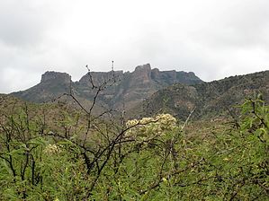
View of Eastern Supes by Tim   The hike starts from the trailhead and meanders south through a field of cholla cactus very similar to what one finds on Black Top Mesa near the First Water Trailhead. There are a couple of small washes to cross, but the trail is well cairned. The Globe Ranger station believes in making very large cairns so you shouldn't have any trouble finding your way. The hike starts from the trailhead and meanders south through a field of cholla cactus very similar to what one finds on Black Top Mesa near the First Water Trailhead. There are a couple of small washes to cross, but the trail is well cairned. The Globe Ranger station believes in making very large cairns so you shouldn't have any trouble finding your way.At the 1.0 mile mark, you will come to a large wash that is roughly 75 to 100 feet deep and 100 yards across. This is the eastern end of Tule Canyon. At this point, the trail overlooks a corral in the bottom of the wash. Follow the wide switchbacks down to the bottom of this wash. At the bottom of the switchback is a large white gate which you will want to close and latch behind you. There is a large cairn at the white gate, but no other cairns are to be seen. You will be tempted to proceed due west up the floor of the wash but this is not what you want to do. Instead, follow the corral directly across the wash to a Tonto Forest Wilderness sign and head up another steep trail out of the wash on the south side.
My GPS unit had the trail at 5.1 miles and it took me just under 2.5 hours with several stops for rubbernecking. The way back was much quicker at 1 hour and 50 minutes. All in all, the round trip hike was 10.2 miles and took about 4.5 hours. The trail climbed a net 2000 feet from bottom to top. Gate Policy: If a gate is closed upon arrival, leave it closed after you go through. If it is open, leave it open. Leaving a closed gate open may put cattle in danger. Closing an open gate may cut them off from water. Please be respectful, leave gates as found. The exception is signage on the gate directing you otherwise. Check out the Official Route and Triplogs. Leave No Trace and +Add a Triplog after your hike to support this local community. One-Way Notice This hike is listed as One-Way. When hiking several trails on a single "hike", log it with a generic name that describes the hike. Then link the trails traveled, check out the example. | |||||||||||||||||||||||||||||||||||||||||||||||||||||||||||||||||||||||||||||||||||||||||||||||||||||||||||||||||||||||||||||||||||||||||||||||||||||||||||||||||||||||||||||||||||||||||||||||||||||||||||||||||||


