 Route Editor

| Guide | ♦ | 78 Triplogs | 1 Topic |
details | drive | no permit | forecast | 🔥 route |
stats |
photos | triplogs | topic | location |
| 1.2k | 78 | 1 |
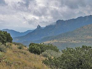
The fun is getting there by Tim   Note: Page stats are for one-way length of #119. Note: Page stats are for one-way length of #119.The Two Bar Ridge Trail is an 8-mile one-way trail in the very northeast corner of the Superstition Mountains near Roosevelt Lake. This trail is also a segment of the Arizona Trail, which travels from Utah to the Mexican border. The trailhead is at the end of Forest Service Road #83. From this trailhead, the hike heads south around Pinyon Mountain, past the Tule Trail intersection, past Two Bar Mountain until it reaches its final destination at the intersection with the Reavis Gap trail, which is roughly 7 miles away. This description only takes the Two Bar Ridge Trail as far as its intersection with the Tule Trail. (An out and back trip of just 3.4 miles each way or 6.8 miles.) Completing the entire trail would require a strenuous 15.2 mile out and back or an overnighter. Most likely, this trail could be used as yet another access to the Reavis Ranch area and a point-to-point hike. After driving 2.5 hours from central Phoenix, Carolyn and I headed out on this seldom-traveled trail. The section to the Tule Trailhead could best be described in 3 segments. The first is a gradual 500 climb up and around Pinyon Mountain. The second is the steeper 600-foot descent down to the creek bed at the bottom of Tule Canyon. The final segment is a gradual 500-foot climb back up to Two Bar Ridge and the intersection with the Tule Trail.
The second section heads 600 feet down the south side of Pinyon Mountain to the beginning of Tule Canyon. The trail is relatively steep, full of scree, and covered with cacti. The footing isn't the best and the seldom traveled trail is easy to lose so keep your eyes open for cairns. This section bottoms out at the creek bed and there are several dry wash crossings. The trail always crosses perpendicular to the creek so don't give in to the natural desire to follow the creek bed as it will take you off course. The third segment is another gradual 500 foot uphill back to the formal Two Bar Ridge. More scree adorns this trail until you top out just southeast of hilt #5004. From there it is a nice gentle stroll down to the Tule Trail intersection. From the trailhead to the Tule Trail intersection took Carolyn and me roughly 1 hour and 50 minutes, but we had stopped frequently. The return trip took the same amount of time. While the return trip had two downhill sections, the uphill portion required more "photo opportunities". (smile) Some day we'll take the trail to its intersection with the Reavis Gap Trail #117, although this portion looks to be much more challenging. The topo map indicates that the trail heading south from the Tule intersection has a major 1,000-foot descent and a 1,000-foot ascent, which will undoubtedly be on more scree, which will make for one "entertaining" afternoon I'm sure. Be what may, the return trip was uneventful and followed by the obligatory beers with the friendly folks at the Quail's Nest Bar which is located roughly 4 to 5 miles south of the FS Road #83 and Hwy 188 intersection on the east side of the road by a Texaco station I believe. An obligatory stop on the way home for any venture in this region. Check out the Official Route and Triplogs. Note This is a moderately difficult hike. Leave No Trace and +Add a Triplog after your hike to support this local community. One-Way Notice This hike is listed as One-Way. When hiking several trails on a single "hike", log it with a generic name that describes the hike. Then link the trails traveled, check out the example. | ||||||||||||||||||||||||||||||||||||||||||||||||||||||||||||||||||||||||||||||||||||||||||||||||||||||||||||||||||||||||||||||||||||||||||||||||||||||||||||||||||||||||||||||||||||||||||||||||||||||||||||||||


