Rainbow Valley Trail - Estrella Mtn RP, AZ | HikeArizona


Rainbow Valley Trail - Estrella Mtn RP, AZ

Guide 130 Triplogs Mine 0 2 Topics
 
2.9 of 5 
Fav
Wish
0
details
drive
permit
forecast
route  
stats
photos
triplogs
topics
location
255 130 2
Statistics
tap icons for details
Difficulty 1.5 of 5
Route Finding 1 of 5
Distance One Way 4.1 miles
Trailhead Elevation 1,018 feet
Elevation Gain 348 feet
Accumulated Gain 593 feet
Avg Time One Way 2.5 hours
Kokopelli Seeds 6.08
feature photo
Photos Viewed All MineFollowing
Will recalculate on button tap!
16  2022-12-15
Maricopa Trail - Estrellas to PIR
kingsnake
5  2022-07-10
EMRP Rainbow Toothaker Loop
Nightstalker
1  2022-07-07
EMRP Rainbow Gadsden Loop
Nightstalker
2  2022-04-23
EMRP Heart Loop
Nightstalker
16  2022-03-06 astrobrewer
12  2021-01-01
Coldwater Trail - Estrella Mtn RP
kingsnake
6  2019-12-07
Quail Trail - Estrella Mtn RP
Hippy
5  2019-08-31
Horseshoe Trail - Estrella Mtn RP
DarthStiller
Page 1,  2,  3,  4
Author
author avatar Guides 24
Routes 19
Photos 416
Trips 1,910 map ( 11,170 miles )
Age 53 Male Gender
Location Phoenix,Az
Associated Areas
list map done
Phoenix Region
Historical Weather
Trailhead Forecast
Radar Map
Expand Map
Preferred Oct, Nov, Dec, Jan → 7 AM
Sun  6:45am - 6:34pm
Official Route
 
12 Alternative
 
 Water
Nearby Area Water
[ View More! ]
Fauna  Nearby
Flora  Nearby
Meteorology  Nearby
Named place  Nearby
Culture  Nearby
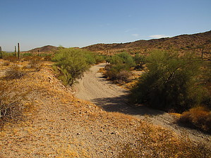
You'll Be Coming Around the Mountain When You Come
by mt98dew

 
Overview
Estrella Mountain Regional Park is located about 20 miles west and south of Phoenix in the foothills of the Estrella Mountains. It was established in 1954 with the purchase of 800 acres. Today, the Estrella Park stretches for almost 20,000 acres. It has a wide range of amenities including horseback riding, a rodeo arena, golfing, fishing, baseball diamonds, a 65-acre grass picnic area, and trails for hiking and biking. The park has 12 trails that extend for 33 miles into the Park.

Hike
The Rainbow Valley Trail (RVT) starts from the west end of the parking lot near a large board with a map of the area. A few feet past the map you will come to the first of four trail junctures. (All the trails are well signed so there should be no confusion as to which trail you are on. And, if you grab a map of the park trails, you will be able to see how all the trails interconnect and be able to devise your own hike). The RVT continues west past this juncture ascending gradually to a ridge directly in front. At this point, there is another juncture with a trail heading off to the north. The RVT continues west and for about the next two miles wraps itself around the mid-level base of the mountain. The trail will rise and fall gradually during this portion never getting high enough to crest the mountain and only briefly touching the desert floor. As you are following the contours of the mountain you'll notice to the north and west the White Tanks off in the distance. Closer by, is the Estrella Golf Course. And just to the south of the golf course, at the base of the mountain, you'll see what looks to be an old water tank and the foundations of a structure. As you hike along the RVT there is another trail juncture at 0.75. This trail, the Quail Trail, heads off to the north and will pass just to the east of these remnants. At the 1.6 mile mark, the trail will start winding toward the south, still maintaining a decent enough elevation that you can view the desert landscape to the west.

The trail eventually works its way down to a major wash which it has to transverse. However, this will be one of the easiest crossings of a large wash that you'll ever do. The trail has been cut into both sides of the wash for easy entry and exit, no scrambling is needed. At 2.75 miles the RVT intersects with the Dysart Trail. The Dysart Trail is a great trail to take if you are looking to do a hike in the 4-5 mile range. You can do a small loop incorporating this trail along with the Toothaker Trail. However, if you are looking for mileage or you simply want to complete the RVT you need to continue south past the Dysart. For the next 0.75 miles, the trail will do some gradual to mild climbs. Nothing serious, but more than you will have experience before this point. At 3.75 miles you will have reached the highest point on the trail, about 1350 in elevation. From here it's all downhill. Literally. The RVT ends at 4.2 miles where it connects to the Toothaker Trail. This last section of the hike is kind of nice because it is one of the few spots on the trail where you can do a 360 and not see signs of human habitat.

At this point you fave several options. You can return the way you came, as in and out. You can turn south on the Toothaker and head deeper into Estrella Park. Or you can take the Toothaker north. Taking the Toothaker north will take you directly back to the RVT TH for a loop of about 6.3 miles.

Water Sources
There is water at the trailhead on the west side of the rodeo arena, just a few hundred feet away. There are also restrooms there.

Check out the Official Route and Triplogs.

Leave No Trace and +Add a Triplog after your hike to support this local community.

2014-06-17 mt98dew
  • Estrella Baseline 2013 Map
    area related
    Estrella Baseline 2013 Map
  • 2020 Estrella Park Info
    area related
    2020 Estrella Park Info
  • 2020 Estrella Park Trails Map
    area related
    2020 Estrella Park Trails Map

One-Way Notice
This hike is listed as One-Way.

When hiking several trails on a single "hike", log it with a generic name that describes the hike. Then link the trails traveled, check out the example.
WARNING! Hiking and outdoor related sports can be dangerous. Be responsible and prepare for the trip. Study the area you are entering and plan accordingly. Dress for the current and unexpected weather changes. Take plenty of water. Never go alone. Make an itinerary with your plan(s), route(s), destination(s) and expected return time. Give your itinerary to trusted family and/or friends.

 Permit $$
Maricopa Regional Parks - 2021 [ fees ]

$7 per vehicle,$85 annual or trade your first born for the life pass

$2 walk, bike or horse ride into park

2021 [ hours ] - varies by park & season


 Directions
or
or
 Road
Paved - Car Okay

To hike
From central Phoenix head west on I-10 towards California. Take the Estrella Parkway exit and head south. Continue about four miles or so to West Vineyard Avenue. Turn left on Vineyard, you'll pass a golf course. Keep your eyes peeled for the right turn into the park soon after the golf course. Take Casey Abbot Dr. and follow it around the perimeter of the park. This will eventually turn into 143 Dr. as it heads south and lead to the horse staging area. To get to the Rainbow Valley TH you will want to park west of the horse arena.
page created by kingsnake on Jun 17 2014 1:20 pm
helpcorrectionissue

end of page marker