Route Editor

| Guide | ♦ | 27 Triplogs | 0 Topics |
details | drive | no permit | forecast | route |
stats |
photos | triplogs | topics | location |
| 140 | 27 | 0 |
Canyons are inherently risky. Flash floods occur without notice on sunny days. Technical skills & surrounding topography knowledge required yet does not eliminate risk.
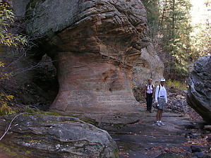
A forested limestone canyon by J&SHike  Kelly Canyon is a beautiful canyon located about ten miles south of Flagstaff. Kelly Canyon is a beautiful canyon located about ten miles south of Flagstaff.You'll want to do this hike in the spring through late fall due to snow in the winter months. We did this hike in June to take advantage of the cooler temperatures near Flagstaff. To get there, take I-17 south out of Flagstaff about 10.5 miles and take the Kelly Canyon Rd. Exit. Turn right onto Kelly Canyon Rd. and drive for half a mile until you are at a stock tank. Take a right (north) off the main dirt road you are on and proceed until the road splits. Here, if you take the road to the right, you will drive about 0.2 miles till you come to an old cabin on top of a hill; you can park here like we did and walk down into the drainage leading to Kelly Canyon. Another option is when the road splits to keep going straight until the road starts to go up and park here; this will save you about an eighth to a quarter-mile in the distance you'll have to hike to get into Kelly Canyon. After following the drainage north, you will come into Kelly Canyon. Take a left and start down, there's a game trail when you go into the canyon on the north side, but I wouldn't recommend it because it takes you up and away from the canyon. There is a trail through the creek bed that peeks out here and there. The path does get better a little ways down the canyon and eventually becomes a mountain bike trail that crisscrosses the creek. Upon doing some research before we set off to this canyon, we found that it is also home to "Rock Jocks", and the evidence, albeit slight, is there; you'll notice the chalk on some of the walls when you head down the canyon. This presence is less and less as you head down the canyon. I guess this place is pretty famous for rock climbers, but we saw no one there and no trash, just some repelling rope stashed in a small cave. As you make your way down the canyon, try at least some of the time to stay at the bottom. Otherwise, you miss some of the refreshing rock features along the way. Water is scarce here unless you're here in early spring with the snowmelt-fed creek. There were some small pools of water, but you'd have to do some filtering if you wanted some.
The canyon floor was full of wildflowers, wild rose (Fendler Rose), Morning glories, Rocky Mt. Iris, Yellow Columbine, and more. The greenery was beautiful. Lady ferns formed a carpet between the Ponderosa Pine trees and Douglas-Firs. Occasional Aspen trees dotted the canyon floor. Lizards, too numerous to mention, scrambled everywhere. In the pools, you will find Salamanders, Crayfish, and Tadpoles. At the confluence of Pumphouse Wash, we found Garter snakes in and around the pools of water. Check out the Official Route and Triplogs. Leave No Trace and +Add a Triplog after your canyon trip to support this local community. | |||||||||||||||||||||||||||||||||||||||||||||||||||||||||||||||||||||||||||||||||||||||||||||||||||||||||||||||||||||||||||||||||||||||||||||||||||||||||||||||||||||||||||||||||||||||||||||||||||||||||