 Route Editor

| Guide | ♦ | 21 Triplogs | 0 Topics |
details | drive | permit | forecast | 🔥 route |
stats |
photos | triplogs | topics | location |
| 277 | 21 | 0 |
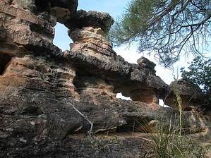
Rings of joy by pbaenzig   Telephone Trail #72 is a short, steep, and lovely trail in the upper Oak Creek Canyon leading to the East Rim. It's a trail for hikers, not for wimps or flip-flop walkers, but the views more than offset the trail's roughness. Telephone Trail #72 is a short, steep, and lovely trail in the upper Oak Creek Canyon leading to the East Rim. It's a trail for hikers, not for wimps or flip-flop walkers, but the views more than offset the trail's roughness.Four similar trails climb up to the East Rim within a few miles from each other. The southernmost trail is Thomas Point Trail #142, starting at the Call O'The Canyon fee parking area, which is also the trailhead for the much more famous West Fork Trail. Going north in the sequence are Telephone Trail #72 (0.55 miles from Call O'The Canyon), Harding Spring Trail #51 (1.2 miles from Call O'The Canyon and opposite Cave Spring Campground ) and finally, just before the switch-backs, Cookstove Trail #143 ( 2.35 miles from Call O'The Canyon and opposite Pine Flat Campground). All four trails are around a mile long and gain about 900 feet in elevation. In my opinion, Telephone Trail #72 is the most interesting trail of the four, albeit the most demanding, followed by Thomas Point Trail, Harding Spring Trail, and finally, Cookstove Trail (which I call a 900-foot staircase with six landings).
Once you reach the first high point of the ridge, the hiking becomes easier -- for a while. The sandstone is flat enough to give the impression of a primitive road. (It's not a road though, it just looks like it). You're now following the ridge, enjoying fantastic views in all directions. You're partially in the sun, but there are plenty of trees to provide some shade on a hot day. You're going to be following this ridge to the top, just dropping down in a few spots where the ridge top becomes impassable. The trail is easy to follow, well marked with hiker made cairns, but is relatively treacherous at times. While hiking on the flat area of the ridge, you'll come to the "Peep Holes," windows in a reef of white sandstone. This little feature alone is worth the entire hike. After the Peep Holes, the trail gets rougher again. It still mostly follows the ridge, but it's getting quite steep. And after a while, the ridge merges in the generally very steep mountainside, and you're scrambling up a steep forest floor. It's not so steep that you must use your hands, but it requires care when placing your feet. When you're coming back down, you will find walking sticks very helpful (I didn't bring mine and walked down VERY slowly). A short distance further, and you're on top of the Rim, marked by a larger than normal cairn. If you turn right, following the Rim, you come to a good viewpoint in less than 0.1 miles. You have views up and down Oak Creek Canyon and to the San Francisco Peaks north of Flagstaff. From the large cairn, there is a faint trail going east. It might conceivably connect with one of the two adjoining trails (Thomas Point or Harding Spring trails). I didn't have a map with me, so I decided to leave this investigation for another day. It took me about 1 1/4 hours to get to the top, with a fair number of stops for catching my breath and picture taking. The GPS measured the trail as being 1.3 miles long, one way, and showed an elevation gain of just short of 1000 feet. Time down was a bit more than half an hour, moving right along. This hike's parking area is on 89A, 10.9 miles north from the Sedona "Y," the intersection of highways 179 and 89A. From the "Y," you drive north towards uptown Sedona and Flagstaff.
Check out the Official Route and Triplogs. Leave No Trace and +Add a Triplog after your hike to support this local community. One-Way Notice This hike is listed as One-Way. When hiking several trails on a single "hike", log it with a generic name that describes the hike. Then link the trails traveled, check out the example. | ||||||||||||||||||||||||||||||||||||||||||||||||||||||||||||||||||||||||||||||||||||||||||||||||||||||||||||||||||||||||||||||||||||||||||||||||||||||||||||||||||||||||||||||||||||||||||||||||||||||||||


