 Route Editor

| Guide | ♦ | 13 Triplogs | 0 Topics |
details | drive | permit | forecast | 🔥 route |
stats |
photos | triplogs | topics | location |
| 74 | 13 | 0 |
Just Hard by joebartels   Harding Springs Trail is named after a settler that occupied the area long ago. I'm not sure "spring" is appropriate as you don't pass a spring on this trail. It's a general reference to the trail taking off "near" a spring. Cave Spring is located across 89A in the campground. Harding Springs Trail is named after a settler that occupied the area long ago. I'm not sure "spring" is appropriate as you don't pass a spring on this trail. It's a general reference to the trail taking off "near" a spring. Cave Spring is located across 89A in the campground.The trail takes off north of the campgrounds and across 89A. Now it takes off directly across a Red Rock Pass purchasing station. Parking is not permitted at the station.
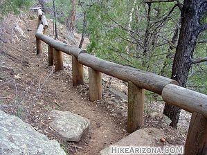
The trail takes off and quickly makes a switchback. It soon goes under a power or telephone line and keeps going up. The next switchback is a lot further than expected. I was beginning to wonder if this trail went to the rim or just over to Cookstove. Indeed, the rim is reached further on after a couple more switchbacks. The second noticeable switchback is one you don't want to miss. The trail turns right just before falling off the edge of a cliff. Next comes a large log-rail. There's a similar rail on the Cookstove Trail. None of which seem needed by any means. It's not that much steeper here than the rest of the trail. Maybe it's for tying up horses to rest, but I don't know that for a fact. Although it's a Hard"e" hike it's short and over soon. The trail breaks onto the rim with little excitement. Views aren't great from here, just a bunch of trees. Don't get me wrong, the trees are nice. There just aren't good distant views. Continue on a ways over and to the right to a lookout. The book Sedona Hikes states that views from atop this trail are better than the Cookstove. I'll disagree. I enjoyed the Cookstove Trail much more. The views along the way and atop blow away this trail in my opinion. Once on the rim, you can head across on the HC Rim Trail.
Coconino FS Details This trail originally was one of several that provided a way for cattlemen to drive their stock in and out of Oak Creek Canyon. For today's hiker, that means it's wider than most Oak Creek Canyon trails and not as steep as some. So, if you're looking for a gradual climb to the canyon rim, complete with rest stops along the way where you can enjoy the view both up and down canyon, you've found it. All of Harding Springs Trail is in the shade of a mixed conifer forest characteristic of central Arizona canyons. That adds another to this trail's already impressive list of pluses by keeping it reasonably cool in summer. And when you top the rim, you have the option of continuing either north to Cookstove Trail or south to Thomas Point Trail to complete a loop hike. Then again, you may want to go back by the same friendly route that brought you here. Check out the Official Route and Triplogs. Leave No Trace and +Add a Triplog after your hike to support this local community. One-Way Notice This hike is listed as One-Way. When hiking several trails on a single "hike", log it with a generic name that describes the hike. Then link the trails traveled, check out the example. | |||||||||||||||||||||||||||||||||||||||||||||||||||||||||||||||||||||||||||||||||||||||||||||||||||||||||||||||||||||||||||||||||||||||||||||||||||||||||||||||||||||||||||||||||||||||


