 Route Editor

| Guide | ♦ | 13 Triplogs | 1 Topic |
details | drive | no permit | forecast | 🔥 route |
stats |
photos | triplogs | topic | location |
| 158 | 13 | 1 |
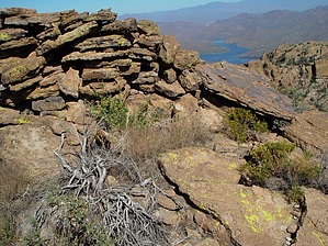
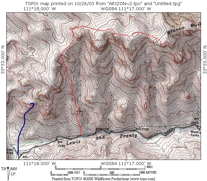
Ride em Cowboy by joebartels  Bronco Butte sits on the southeast corner of Horse Mesa. It's a great destination hike offering 360 degrees of outstanding views. The route, terrain, and exposure can be brutal. It's likely you won't want to return, once is probably enough. Bronco Butte sits on the southeast corner of Horse Mesa. It's a great destination hike offering 360 degrees of outstanding views. The route, terrain, and exposure can be brutal. It's likely you won't want to return, once is probably enough.The route is cairned and worn in sections. Topographical map reading skills are necessary. I strongly suggest studying the map before attempting this hike. Your route may vary. Download and use the "Official Route" for best results. It was revised in 2014 and differs a bit from the 2003 map linked above.
From SR88: Read the directions below. I took off from here and forced up the escarpment. I did find the route on the return and it's plotted on the map. The bad news is it's pretty tough to find. In addition, it's very light and lightly cairned in the lower sections. Okay here's my feeble attempt to describe: Instead of forging up immediately, hike the road east for about five to ten minutes. Just start heading up, you'll come to a deck that flaunts an old road. I suspect a service road for the power lines. If you're lucky enough to find the metal power wire support-structure with a "supporting cable to the ground angled out north" the trail starts just north (maybe a tad west). However, it's so faint and hard to follow you might as well forget it. You're better off just locking your GPS in on where the trail crosses the "+" on the map. It's pretty distinctive from there to the major ascent. As mentioned I only found the entire length of this path on my return, I battled the elements more than necessary going up. The major ascent up the wash is pretty much horrid at best. I can't speak for the right of the wash, maybe there's something easier on that side. Approaching I figured the left was easier so that was my ascent. I darted up to quickly and had to come back down a bit. If you don't choose wisely you might face catclaw on a 50-degree grade of soft soil with prickly pair, cholla & saguaro only to break your fall. Once you've conquered the ascent a fence with a gateless walkthrough greets you. I chuckled, as you'd think there'd be some evidence of a trail. However, it looked like nobody had walked through in 10 years. Once on top, you'll be thinking the worst is over. It is, but it isn't a casual walk over to the butte by any means. So far you've gained about 1100 feet in elevation, there's 900 more to go. Be on the lookout for a cairn shortly up to the right. This is your easy ticket for the next half-mile stretch. The cairns will turn into a path, go around a bend, and then take you to your next adventure. Once again, study the map. When the cairns seem to peter out in a grassy left-turning slope, just forge up. It's hell. You can barely see where you're stepping due to the tall grass. If you come unprepared like me the grass seeds'll prick you in your socks and boots. I'd recommend jeans taped at the bottom or a spring hike when the grass is green. This was so annoying. The torture got to a point where I became numb. Be safe and take it easy. Beware, rocks under the grasses could twist an ankle with a bad step. Continue nearly a mile through this grass/rock mix. First, you'll notice the MCSO radio repeaters and solar panels. Bronco Butte is easy to spot to the right, it looks tough to conquer. As you near the butte it becomes less of a concern, you can tackle it from multiple angles. I went on the outer fin. Going up I turned to my right only to notice the 2000-foot sheer drop. I guess my mind was elsewhere because it startled me. Atop Bronco Butte the views include: Superstition Peaks 5024 & 5057, Camelback Mountain, Red Mountain, the Four Peaks, Apache Lake, the Sierra Ancha Mountains, Castle Dome, an overview of the heart of Fish Creek, Black Cross Butte & a rare opportunity to see the Painted Cliffs! There's a pile of wobbly rocks on the highest point making it higher yet. You might want to think twice before walking over to the edge for a view. The slab of rock is slanted downward and a bit nerve-wracking. Note The 2000-foot sheer drop is a slight exaggeration. 37.8% avg grade down to Lewis and Pranty Creek. Gate Policy: If a gate is closed upon arrival, leave it closed after you go through. If it is open, leave it open. Leaving a closed gate open may put cattle in danger. Closing an open gate may cut them off from water. Please be respectful, leave gates as found. The exception is signage on the gate directing you otherwise.
Check out the Official Route and Triplogs. Note This is a more difficult hike. It would be unwise to attempt this without prior experience hiking. Leave No Trace and +Add a Triplog after your hike to support this local community. | ||||||||||||||||||||||||||||||||||||||||||||||||||||||||||||||||||||||||||||||||||||||||||||||||||||||||||||||||||||||||||||||||||||||||||||||||||||||||||||||||||||||||||||||||||||||||||||||||||||||


