 Route Editor

| Guide | ♦ | 65 Triplogs | 0 Topics |
details | drive | permit | forecast | route |
stats |
photos | triplogs | topics | location |
| 264 | 65 | 0 |
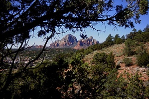
Screamin' views by joebartels   Get ready Arizona! Experience one of Arizona's best! The Huckaby Trail! My first venture on the Huckaby Trail left me with good memories. From Schnebly Hill Road the trailhead is well built. Plenty of parking, good trail information, and a restroom. This trailhead is a few hundred yards away from the original trail to make room for parking. You could park in the lower parking area and save a few steps. Get ready Arizona! Experience one of Arizona's best! The Huckaby Trail! My first venture on the Huckaby Trail left me with good memories. From Schnebly Hill Road the trailhead is well built. Plenty of parking, good trail information, and a restroom. This trailhead is a few hundred yards away from the original trail to make room for parking. You could park in the lower parking area and save a few steps.A few cairns and signs guide you on your way in the beginning. The first of two descents are encountered right away. Early 1999 this was bulldozed to make the trail flow easy. On your way back up the other side, you can look over and see the trail going down. I'm sure some will complain about the width of the trail and how it isn't natural at that point. All I have to say is if you don't get out there and volunteer don't complain.
Views to the east offer Capitol Butte along with Coffeepot Rock. About a mile into the hike the trail gets closer to busy Highway 89A. The peace and quiet along with the Junipers fade away. Oak Creek opens up below with awesome birds-eye views. Following along high above Oak Creek you get a beautiful view of Steamboat Rock in front of Wilson Mountain. As the trail begins descending you might find it hard to believe this is also a mountain bike trail! Once down to creek level you are following a section of the old Inner Gorge Trail. This will take you Northeast to our turn-around point where the creek bends to your right. From this point, you look up to a spectacular view of the Midgely Bridge. You can continue to skirt the creek and hop the rocks to close by Grasshopper Point and the very popular Allen's Bend. Return by the same route. I found it amazing to travel so quick and easy from Schnebly Hill Road to just below the Midgley Bridge. I could not convince myself the elevation loss on this trail was only 200 feet. After thoroughly studying the topographical maps I found this to be true. I even did a computer-generated trail and it came up -201. All in all, this is a great trail. Easy enough for most and super multi-views along the way. Enjoy! Camping According to the 2018 FS map camping is not allowed on any portion of this trail.
Check out the Official Route and Triplogs. Leave No Trace and +Add a Triplog after your hike to support this local community. One-Way Notice This hike is listed as One-Way. When hiking several trails on a single "hike", log it with a generic name that describes the hike. Then link the trails traveled, check out the example. | ||||||||||||||||||||||||||||||||||||||||||||||||||||||||||||||||||||||||||||||||||||||||||||||||||||||||||||||||||||||||||||||||||||||||||||||||||||||||||||||||||||||||||||||||||||||||||||||||


