Route Editor

| Guide | ♦ | 22 Triplogs | 5 Topics |
details | drive | permit | forecast | route |
stats |
photos | triplogs | topics | location |
| 250 | 22 | 5 |
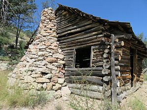
A historic cabin with a side of catclaw by ShatteredArm   Overview OverviewAn historic cabin and mine in the middle of the Galiuro Mountains, where the Powers family attempted to mine gold in the early 20th century. History On February 10, 1918, deep in the Galiuro Mountains, a shootout occurred at Jeff Powers' cabin. A posse of Graham County lawmen arrived at the cabin with the intent to apprehend Powers' sons Tom and John, who were accused of draft dodging. The Powers believed they were out to take over their mine, and shots were exchanged between the Powers and the posse. Jeff Powers was killed, along with the Sheriff and two deputies; the Powers brothers were wounded, but escaped, leading to the largest manhunt in Arizona's history.
Approach Due to its remote location, Powers Cabin generally involves an overnight hike. The most common, and easiest, approach is from the north via Powers Garden and West Divide trails. This guide begins at the junction of Powers Garden and Rattlesnake trails. The easiest way to get here is to start at Deer Creek TH, take Tortilla Trail to Powers Garden, and then Powers Garden trail the rest of the way. Hike From the junction of Powers Garden and Rattlesnake trail, head south along Powers Garden trail. The junction is in the bottom of Rattlesnake Canyon but leaves the canyon via a nicely shaded side drainage that may contain a trickle in the spring. The trail generally follows the bottom of the drainage for the first half mile, but then begins contouring up a ridge to the west. After wrapping around the ridge, the vegetation changes to manzanita and gets a little more overgrown. The trail tends to be pretty easy to follow and relatively free of scratchy plants until the West Divide junction. 1.1 miles from the bottom of Rattlesnake Canyon, you arrive at a saddle with sweeping views of Kielberg and Rattlesnake Canyons. This is the junction with the West Divide Trail and the southern terminus of Powers Garden trail. From here, it is less than half a mile down to the Powers Cabin spur trail, but you can generally expect to encounter lots of catclaw the rest of the way. The whole hillside is covered with it. The spur trail is an unmarked, but obvious, trail that takes a sharp left and follows the contour to the cabin. Pick your way through even more catclaw to get to the cabin. There isn't much left inside the cabin, but the structure is impressive. Continue following the trail across the drainage to get to the mine, where there are some mine shafts, old structures, and mining equipment that are worth taking a look at. Water Sources Water can often be found in parts of Rattlesnake Canyon. Rattlesnake Spring, a quarter mile or so north of the Rattlesnake Trail junction, sometimes has water. Powers Garden Spring often has water, and Holdout Spring is even more reliable. Camping Good campsites can be found at Powers Garden, near Holdout Spring and upper Rattlesnake Canyon, at the junction of Powers Garden and Rattlesnake trails, and there is a nice campsite in Kielberg Canyon along West Divide Trail less than a mile south of the Powers Cabin spur trail. Check out the Official Route and Triplogs. Leave No Trace and +Add a Triplog after your hike to support this local community. | ||||||||||||||||||||||||||||||||||||||||||||||||||||||||||||||||||||||||||||||||||||||||||||||||||||||||||||||||||||||||||||||||||||||||||||||||||||||||||||||||||||||||||||||||||||||||||||||||||||||||||