Route Editor

| Guide | ♦ | 96 Triplogs | 2 Topics |
details | drive | no permit | forecast | 🔥 route |
stats |
photos | triplogs | topics | location |
| 850 | 96 | 2 |
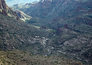
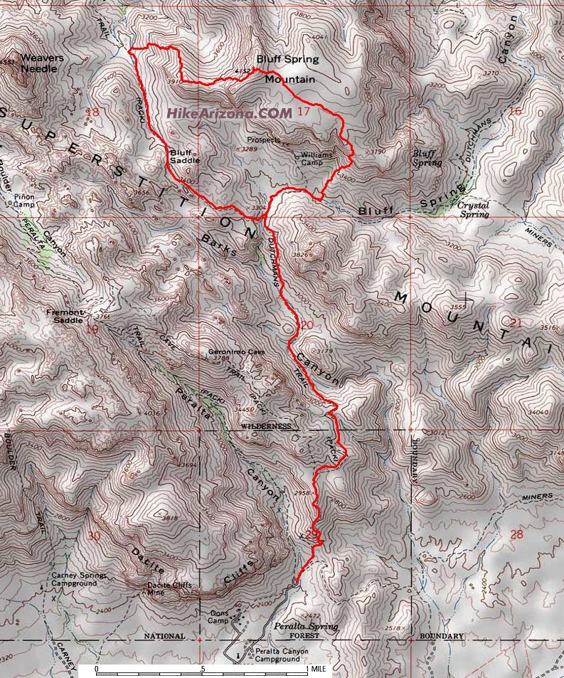
Joy - a bonus for the soul by joebartels  Overview OverviewHere is a moderate trip into the heart of the western Superstition Wilderness and tops Bluff Spring Mountain. Study the map and take a copy with you. Many of the high points in the wilderness offer great views, but there always seems to be this gentle giant obscuring part of the view. This trip is a cure for the obscured. Jeans aren't necessary though I do suggest a step up from teva sandals. Be sure to go November through February or the snakes will be out. Route Bluff Spring Trail #235, off-trail up the south slope of Bluff Spring Mountain, off-trail down the west slope, Terrapin Trail #234, and back on #235.
From the Peralta Trailhead: Take off to the immediate first junction and head up the Bluff Spring Trail. Pass up the Terrapin Junction and keep on truckin. A little over a half-mile after the junction you will notice a wide ridge coming down from your left. When the ridge comes all the way down to the creek beside you it's time to head on up. I've accessed Bluff Spring Mountain from numerous points over the years. This is among the easiest and shortest routes up or down. I do recommend using the map below and going counterclockwise using this as your up route. Keep looking forward for a good route and you'll be fine. Midway up the eye of Miners Needle comes into view. There are two small ten-foot walls to conquer. Both can be bypassed for the most part. Or just go over. It's fun and neither presents much trouble. When you top out you're on a lower deck. The peak is three-quarters of a mile northwest and it's another 300 feet up. You might consider working topo point 4041 into your loop. Which is the best view of Bluff Spring Mountain Canyon. The stroll over to the peak is on my list of all-time favorites. The peak itself offers great views. The shortest option would be to return the way you came. However, the loop shown in the map is fun and barely further in distance. Head down to the Terrapin Trail as shown on the map. Hike back to the Bluff/Terrapin junction and backtrack on the Bluff Springs Trail to the trailhead. You might consider putting a little more meat on the bone. If you are familiar with Weavers Cross Cut this is a better loop. Better yet if you're familiar with Dacite Mesa and the reverse jag down to Peralta Trailhead.
Check out the Official Route and Triplogs. Leave No Trace and +Add a Triplog after your hike to support this local community. | ||||||||||||||||||||||||||||||||||||||||||||||||||||||||||||||||||||||||||||||||||||||||||||||||||||||||||||||||||||||||||||||||||||||||||||||||||||||||||||||||||||||||||||||||||||||||||||||||||||||||||||||