Route Editor

| Guide | ♦ | 113 Triplogs | 4 Topics |
details | drive | no permit | forecast | 🔥 route |
stats |
photos | triplogs | topics | location |
| 423 | 113 | 4 |
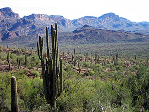
Over then UP UP UP! by IRIE_LION  2026 March Changes 2026 March ChangesThe Carney Spring Trailhead is closed. This hike now begins at the Lost Goldmine TH. It is 0.5 mile longer one-way and 16 feet less AEG. 2015 Changes The Carney Springs Trailhead has transformed from rarely utilized to heavily used. The first leg of this hike shares the trail with the popular Wave Cave. Parking might be a challenge.
This hike starts from the Carney Springs Trailhead, just 1.2 miles south on FS77 from the Peralta Trailhead parking lot. There is a small turnaround there for parking, which is small and limited. However, this trailhead's usage is nothing compared to its neighbor, so don't worry. There is no sign for this trailhead. The access to the road has been gated off to keep motorized vehicles out, but is open to foot travel. Once you walk through the gate, follow the old rough rocky road north, heading to the 2 ravines through some old campsites, there's a lot of rock campfire pits everywhere on the sides of this road. Keep following the road until you run into a barbed wire fence that is the wilderness boundary. There's a slot through the fence which states to close the gate behind you, but it isn't really a gate, more like a walk-through of a barbed wire fence. From here, the trail is pretty defined and shouldn't be hard to follow until you come to a cairn. Look to your left. There are man-made rock and concrete fountain structures, which are Carney Spring, for which the trailhead is named. This used to be a picnic area. Old rusty cans from days passed linger around the area. The first time coming to this spring, which only had a limited amount of old water (from rain), I saw a Gila Monster going to it for a drink. From this area is the hardest part is finding the right trail. The trail is somewhat overgrown looking, but from the spring, your general direction should be northeast to the ravine on your right. The pipe running behind the spring should be on your left. Once ascending the west side of the ravine, there is some bedrock in areas, but it was pretty well cairned. There were white paint lines, which I'm not a big fan of, but they helped. It's pretty steep in areas, so be careful. Head up until you come to a saddle, but don't get too excited yet, it's a false saddle, and you will be able to see that you pretty much only hit halfway going up. By this point, you'll be panting... Still, a nice view from here, a good place to stop, catch a breath, and hydrate. The trail is cairned directly north, and the trail is visible, so just follow this last stretch of the climb to the top, west boulder saddle. From the top at West Boulder Saddle, the trail heading west on your left is to the Superstition Ridgeline (to Superstition Peak) and beyond if you want to do the ridgeline hike. The one on your right (east) is fainter but heads over to Fremont Saddle. You can also head down a near-extinct trail and head into West Boulder Canyon to Ruth's Willow Spring. I would rate this hike next to the cave trail(descending), but only a little tougher since it's all uphill! Enjoy the climb in this true wilderness. Gate Policy: If a gate is closed upon arrival, leave it closed after you go through. If it is open, leave it open. Leaving a closed gate open may put cattle in danger. Closing an open gate may cut them off from water. Please be respectful, leave gates as found. The exception is signage on the gate directing you otherwise. Check out the Official Route and Triplogs. Leave No Trace and +Add a Triplog after your hike to support this local community. | |||||||||||||||||||||||||||||||||||||||||||||||||||||||||||||||||||||||||||||||||||||||||||||||||||||||||||||||||||||||||||||||||||||||||||||||||||||||||||||||||||||||||||||||||||||||||||||||||||||||||||||||||||||||