Route Editor

| Guide | ♦ | 14 Triplogs | 0 Topics |
details | drive | no permit | forecast | 🔥 route |
stats |
photos | triplogs | topics | location |
| 95 | 14 | 0 |
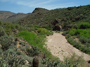
Even Flow by joebartels  I'll save the high perk readers undo agony; move on this isn't for you. I'll save the high perk readers undo agony; move on this isn't for you.Overview This is an off-trail out-n-back hike through the tail end of Cottonwood Creek. The area covered is from just over half-mile south of Cottonwood Camp to Saguaro Lake/Salt River. This description starts about a half-mile down from the posted trailhead right before the road turns to true 4WD. Add 1 mile to your hike if starting at Cottonwood Camp. Note I wouldn't recommend hiking this creek with heavy rainfall in the forecast. The large creek bed swath wasn't created by any trickles. No solid data here from gauges but I did notice debris around four feet high in the trees. If you're still not convinced whip out a topographical map. Cottonwood Creek is sixteen miles in length and receives nearly all the runoff from the west side of the Four Peaks. It starts way back up past Mud Spring before wrapping around the Wata Ridges.
The hike is simple, head downstream for 4.6 miles to the river/lake. Note the first few steps in the creek bed. It's similar to a gravel road, but it's up to a foot deep in sections. The going is sluggish and it's the entire length of this hike. On the bright side, there's zero bushwhacking involved along the way. There wasn't much wildlife noted on my hike during the hottest part of the day. Hoped to catch a glimpse of a racer but that never happened. The bushes were loaded with bees. Several butterflies darted about and I did scare up a large group of quail. On route, you can't help but notice this is major ATV country. I only encountered two groups of ATVs on the hike, both of which were very friendly. About two miles in the creek bed enters a 1.5 mile stretch of twisted canyon, I call the twist. There are some nice spots for lunch or a break. On the tail end of the twist are a couple of alcoves you might want to explore. Past the twist, the creek bed widens again and the views become more distant. I'm still in disbelief ATVs make it through that section, but they do. There wasn't much litter encountered but I did notice several sections of oil or gas spills. It's only another mile to the river/lake. The water on this outing was a slime bubbling mossy marsh. Not something you'd enjoy cooling off in! Instead of a swim, climb up the right wall for better views. Check out the Official Route and Triplogs. Leave No Trace and +Add a Triplog after your hike to support this local community. | ||||||||||||||||||||||||||||||||||||||||||||||||||||||||||||||||||||||||||||||||||||||||||||||||||||||||||||||||||||||||||||||||||||||||||||||||||||||||||||||||||||||||||||||||||||||||||||||||||