Bartlett Lake is one of the numerous reservoirs along the Verde and Salt Rivers. Twenty-five miles from Carefree this is a close to town recreation site. Coming from Chandler it's a boring two-hour drive through the city. Jojoba Trail was dedicated on National Trails Day June 5th 1993. Built in cooperation with the Federal Bureau of Prisons.
The trailhead is located on the left heading into the Jojoba boating parking lot. From the trailhead, a road is encountered immediately. The trail continues up to the left across the road. Down on your right, you pass a helicopter pad. The trail is loose tiny brown gravel and the footing isn't great. Dips and curves are constant along the trail. Although nearly level in terms of elevation gain the ups and downs never give way.
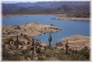
Hiking this trail in June as I did really isn't recommended. In the middle of a hearty drought, the lake was about 20-30 feet low. The piers and adjoining catwalks along the shore sat on dry times. Vegetation along the trail is low lying for the most part with some Saguaros and Palo Verdes. The Saguaros along the trail are remarkably healthy. They don't show the signs of abuse as seen on most trails. Near the 0.8 mile mark, a junction is reached. You have the option of heading out onto a peninsula which I didn't check out. Next is a wash with barricades. Follow the barricades across and pick up the trail on the other side. Soon the trail ends at Rattlesnake Cove Beach. Sure you could have driven here but after a desert hike, it feels great to jump in the lake!
You may wish to extend this hike with the Palo Verde Trail.
WARNING! Hiking and outdoor related sports can be dangerous. Be responsible and prepare for the trip. Study the area you are entering and plan accordingly. Dress for the current and unexpected weather changes. Take plenty of water. Never go alone. Make an itinerary with your plan(s), route(s), destination(s) and expected return time. Give your itinerary to trusted family and/or friends.
To hike Take Scottsdale Road north, passing the Boulders. Scottsdale Road turns into Tom Darlington. Continue through Carefree and turn right onto Cave Creek Road. Follow Cave Creek Road to the turnoff on Bartlett Dam Road. Follow the signs to the lake. Pay the parking fee and continue to the Jojoba boating dock parking lot.
 Route Editor

 Bartlett Lake is one of the numerous reservoirs along the Verde and Salt Rivers. Twenty-five miles from Carefree this is a close to town recreation site. Coming from Chandler it's a boring two-hour drive through the city. Jojoba Trail was dedicated on National Trails Day June 5th 1993. Built in cooperation with the Federal Bureau of Prisons.