Route Editor

| Guide | ♦ | 9 Triplogs | 0 Topics |
details | drive | no permit | forecast | 🔥 route |
stats |
photos | triplogs | topics | location |
| 102 | 9 | 0 |
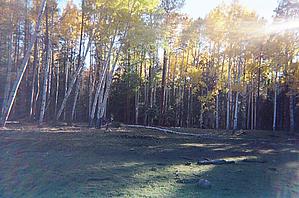
Hannagan Meadow Blue River Loop by arizonaed  This loop, starting from Hannagan Meadow, Foot Creek Trail 76, at 9000 feet of elevation, continuing down to the Blue River and back up to Hannagan Meadow via the KP Creek trail 70 and the North Fork KP Trail 93, is similar to the Steeple Mesa - Grant Creek trail except: this loop cuts off at Mud Spring, at approximately the 24-mile mark, to return via the perennial KP Creek and, for the final 1 1/1 miles, along Highway 181, instead of the seasonal Steeple Creek. Please look at the Steeple Mesa- Grant Creek trail for additional information if you plan this loop. This loop, starting from Hannagan Meadow, Foot Creek Trail 76, at 9000 feet of elevation, continuing down to the Blue River and back up to Hannagan Meadow via the KP Creek trail 70 and the North Fork KP Trail 93, is similar to the Steeple Mesa - Grant Creek trail except: this loop cuts off at Mud Spring, at approximately the 24-mile mark, to return via the perennial KP Creek and, for the final 1 1/1 miles, along Highway 181, instead of the seasonal Steeple Creek. Please look at the Steeple Mesa- Grant Creek trail for additional information if you plan this loop.As with any hike, the concern becomes finding reliable water sources, which is why the hikers detoured at Mud Springs.
P Bar Lake, at mile 4, does make for a very lovely first night after the 5 to 6 hour-long drive from metro Phoenix. Nothing more than a mudhole in October, this area, at just under 9000 feet of elevation, provides scenery complete with fall colors of aspen and mixed conifer, deer drinking from the lake early in the morning, and a great respite from the city life. From P Bar, departing from trail 76, follow the 75-trailhead sign south. Cutting westward across to White Oak Spring and beginning a drop in elevation, off in the distance, a hiker for the first time, views the valley that the Blue River meanders. (About 2 miles past the spring, a small intermittent creek afforded some water before crossing Grant Creek another mile down the trail.) At White Oak Spring, elevation about 7200, Trail 75 continues down in elevation, at an average grade of 12%, eventually paralleling the perennially flowing Grant Creek to the confluence of Grant Creek and the Blue River at mile 14. Trail 75 actually crosses the river, which for these hikers required a bit of rock hopping, not actually fording through the water. At this point, from the trailhead-75, follow FR 281 down 4 miles to the trailhead-73 sign. The Blue River is perennial and offers some excellent views on the river and back up Grant Creek. The dirt road passes several private ranches, including the Post Office of Blue, Arizona. Any good map will show the Box, which is an excellent place to set up camp. Another mile will put you at the 73 trailhead. From this point, transitioning to trail 73, the climb is strenuously steady. For nearly 3 miles to the KP Mesa, the average grade is 11%. However, at night, the KP Mesa, despite its moon-like rocky appearance and low pinyon pine, offers outstanding nighttime star gazing opportunities with visibility for miles in any direction. KP Mesa conjoins into Steeple Mesa, offering the legs a bit of rest from the previous stretch of hiking. Two miles beyond the end of Steeple Mesa, KP Creek trail 70 splits off of trail 73 to head in a southwesterly direction to skirt contouring slopes into the KP Creek Canyon. This trail continues for 3 miles before crossing the perennial running KP Creek, just short of the McKittrick Trail 72. Trail 73 continues, closing following the KP Creek riparian area. One Hundred foot plus tall Ponderosa Pine, conifer, and aspen litters the area, making this canyon very cool, pretty, and isolated. The trail continues up in elevation at a steady incline of about 7%, passing maybe one or two small tributaries of KP Creek. Several creek crossings are necessary before arriving at the North Fork KP trail 93, which splits from trail 70. Trail 93 follows the much smaller north fork past several springs until the creek bed is dry. At this point, the 11 to 13% incline continues for a short distance of about one mile before leveling out at a gentle bend, which brings the hiker to the trailhead. A short 1-1/2 mile walk up the paved road northward on Highway 181 returns the hiker to the 73/76 trailheads. A suggested alternative route: instead of Highway 181, travel from the KP Rim trailhead, 315, back into the forest to the junction of the Steeple Creek 73. Regardless of the route, this area provides many alternatives and hiking trails, all very well maintained. The best source of information and maps, trailhead information, found by these hikers is located at the Apache-Sitegreaves Forest Ranger Office, Alpine District, in Alpine Arizona, and on the Blue Range Wilderness and Primitive Area map, available at a local map or hiking stores. Because of the remote distance, do your research before hiking this area. Perhaps, because of the nature of this loop, the only other human contact was a few passing trucks on the FR 281. Otherwise, outside the occasional jet flying miles overhead, during the day, the hikers enjoyed complete solitude of nature's wildlife and babbling creeks. At the time of this hike and writing, the mixed conifer and aspen are in full brilliant color change, not only in the upper elevations of this hike, but throughout the Blue Range and Alpine areas. Last word of caution: this area is notoriously known for the constant threat of rain and thunderstorms, weather which can change in a short time; do not forget to pack your rain gain. Use Alpine Arizona weather forecast to plan your trip. Check out the Official Route and Triplogs. Note This is a moderately difficult hike. Leave No Trace and +Add a Triplog after your hike to support this local community. | |||||||||||||||||||||||||||||||||||||||||||||||||||||||||||||||||||||||||||||||||||||||||||||||||||||||||||||||||||||||||||