Route Editor

| Guide | ♦ | 33 Triplogs | 0 Topics |
details | drive | no permit | forecast | 🔥 route |
stats |
photos | triplogs | topics | location |
| 606 | 33 | 0 |
Beyond cairns by joebartels   Overview OverviewHike over Black Cross Butte and roller coaster it over to and up Peak 3042. The peak offers rare views of the Salt River Canyon. Return the same route or perhaps take the drainage back. The entire hike is off-trail. The surface varies, but it is easy to travel for the most part. Moderately steep terrain is encountered, but it's short and over quick. Summary Study the map. Next read Black Cross Butte 3351 for tips on attaining the primary obstacle being the butte itself. I varied the course on my route up this time. It's not necessary to go over the butte as it's possible to skirt the upper slopes. However, I think it's easier on the ankles just going over.
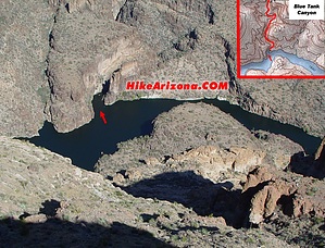
Cairns guide you halfway. The second half was cairn free as of this writing. There are a few ten to twenty-foot sections of path in some of the grassy sections. That aside, the second half is very well preserved. You are far from being the first person to travel the area, but it has a pristine pioneer feel. Peak 3042 looks tough to negotiate. I assure you it's much easier than it seems if you follow the map. Once on top of the peak, you are rewarded with outstanding views of the Salt River Canyon. Circle the edge to get in all the views. Be sure to check out the head on overview of Blue Tank Canyon. That alone was worth the hike, in my opinion. Then again, the route itself is pretty awesome for a day hike! Notes I strongly advise leaving the dogs at home for this hike. There are too many prickly cholla balls. On my first attempt, I wore Teva sandals. It's possible, like nearly every other hike I've done, but boots are preferred for this terrain. On a cool, breezy eighty degrees day in October, I downed a full hundred-ounce water pack. Don't let the 451-foot elevation gain deceive you. The accumulated gain for this hike is over 2800 feet. That's not too rough in itself, but if you get off course, it could get ugly.
Check out the Official Route and Triplogs. Leave No Trace and +Add a Triplog after your hike to support this local community. | ||||||||||||||||||||||||||||||||||||||||||||||||||||||||||||||||||||||||||||||||||||||||