Route Editor

| Guide | ♦ | 10 Triplogs | 1 Topic |
details | drive | no permit | forecast | 🔥 route |
stats |
photos | triplogs | topic | location |
| 113 | 10 | 1 |
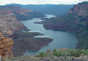
Wicked stroll by joebartels   Overview OverviewThis hike is from Cane Spring Trailhead out to the semi-circle ridge around Hell's Hip Pocket and returns by the same route. You might prefer to make it a loop or backpack and explore the area in detail. The hike is mainly off-trail over fairly easy but uneven terrain. It's not recommended for dogs due to countless cacti encounters. Hike From the trailhead head out on the old jeep road that now serves as the Cane Spring Trail #82. You curve into one drainage/canyon and then skirt over into another drainage/canyon. The road dips through the creek abruptly. At 0.7 miles fork right onto a faint jeep road. Only continue for a tenth of a mile. Turn right and head off-trail dipping through the creek bed and UP the mountain on your right. It's a short bushwhack through the catclaw to the creek bed. Don't hesitate as it's over quick and you won't be dealing with bushwhacking anymore on this hike.
After maybe five minutes of relaxed ridgeline strolling there's a 200 foot gain. That's followed by about another 100-foot dip & gain to topo high point 3509. From here looking south and southeast is a fab view of Hell's Hip Pocket. Continue on the crescent curved ridge to topo high point 3260. Along the way, you will find impressive views of the Salt River below. Upon reaching 3260 it's just over a quarter mile to Hell's Bridge where the smooth ridge gives way to eroded terrain. This hike ends here for now. There's a first-class view of Black Cross Butte across the river. Other great views include Horse Mesa, Peak 3042, Sheep Mountain & the SRP maintenance community near Horse Mesa Dam. Check out the Official Route and Triplogs. Leave No Trace and +Add a Triplog after your hike to support this local community. | |||||||||||||||||||||||||||||||||||||||||||||||||||||||||||||||||||||||||||||||||||||||||||||||||||||||||||||||||||||||||||||||||||||||||||||||||||||||||||||||||||||||||||||||||||||||||||||||||||||||||||||||||||||||||||||||||||