username
X
password
register
for free!
help
 
  🔥

Tortilla Creek North Ridge, AZ

Guide 3 Triplogs  0 Topics
  3.5 of 5  
Fav
Wish
3
details
drive
no permit
forecast
🔥
route  
stats
photos
triplogs
topics
location
28 3 0
Statistics
tap row or icons for details
Difficulty 3 of 5
Route Finding 3 of 5
Distance Round Trip 3 miles
Trailhead Elevation 2,040 feet
Elevation Gain 942 feet
Accumulated Gain 1,100 feet
Avg Time Round Trip 3 hours
Kokopelli Seeds 8.5
 Interest Off-Trail Hiking
 Backpack Possible - Not Popular
feature photo
Photos Viewed All MineFollowing
10  2018-12-22 wallyfrack
4  2017-03-04 AZLumberjack
14  2005-01-06 joebartels
Author
author avatar Guides 264
Routes 2,797
Photos 14,494
Trips 5,894 map ( 29,783 miles )
Age 55 Male Gender
Location
Associated Areas
list map done
Phoenix Region
Historical Weather
Trailhead Forecast
Radar Map
Expand Map
Preferred Jan, Dec, Feb, Nov → 10 AM
Seasons   Early Winter to Late Winter
Sun  6:02am - 6:46pm
Official Route
 
0 Alternative
 
Historic Fire Perimetersacres
🔥 2024 Siphon Fire35.9 mi*
🔥 2019 Woodbury Fire123.8k
🔥 View (All) - over Official Route 🔥
*perimeter length in miles


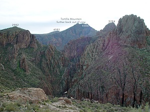
Steep but easy with some views
by joebartels

 
Overview
Hike from the dirt road near topo "x" mark 2055 up to the ridge and over to high point 2982. You could follow the ridge all the way to FS213 (the road to Tortilla Trailhead). Best hiked after recent rains if you'd like to hear the roar of the creek below. It seems if it rains over an inch in a day the tortilla bridge turns into a spillway for a day or two. If it rains two inches in a day the bridge becomes inaccessible. As with all my steep/hillside/ravine/brush type off-trail hikes... they are best attempted only from December into the second week of February or you'll be wrestling snakes galore!


Hike
This hike had been on my want-to-do list for years. Figured I'd hike the ridge near it's origins around Mesquite Flat and follow the ridge over to FS213 or at least to peak 3420. From topo mark 2055 I headed up to the ridge. It's not too steep and the brush is fairly negotiable without incident. I made the mistake of trying to go over the first high point and cliffed out. Before proceeding I couldn't help but absorb all the views. Most I'd seen from various angles but smack dab below was a killer overview of the Peters/Tortilla Creeks confluence.
remove free decal offer
Next, I backtracked down and south around the point I cliffed out. The slope is very steep and probably rather dangerous if you stand around and think about it. Once around the high point, the ridge dips before winding up to peak 2982. Walking along the ridge you can hear the roar of the creek far down below. You get glimpses of Tortilla Creek at various opportunities along the way.

Continuing to peak 3420 or FS213 appears to be possible with easy to moderate effort. I pretty much lost all desire to continue as my hands, ears, and nose were freezing. Which oddly enough was accompanied by sweating. I doubt I'll be coming back as this area wasn't as exciting as anticipated. Nevertheless, it's always fulfilling to cure the curiosity of the unknown.

2005-01-06 joebartels


    Check out the Official Route and Triplogs.
    Leave No Trace and +Add a Triplog after your hike to support this local community.
    WARNING! Hiking and outdoor related sports can be dangerous. Be responsible and prepare for the trip. Study the area you are entering and plan accordingly. Dress for the current and unexpected weather changes. Take plenty of water. Never go alone. Make an itinerary with your plan(s), route(s), destination(s) and expected return time. Give your itinerary to trusted family and/or friends.

     Permit $$
    None


     Directions
    or
     Road
    High Clearance possible when dry

    To hike
    I didn't really pay attention...
    It's shortly after Mesquite Flat. Since you'll need a map or GPS to hike here you'll figure it out pretty easily.
     90+° 8am - 6pm kills
    helpcorrectionissue

    end of page marker