2018
Easy to follow & paved in portions compared to old preserved review.
2000
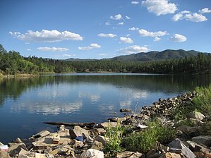
Step out on this trail in June as I did, and summer welcomes you. From the parking loop, pay your dues and head on over towards the lake lookout. The trail takes off from the right and goes down immediately.
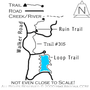
You can follow the trail in either direction. The trail is not clearly marked; there could be better signs and trail maintenance. Not to worry, it's no big deal; you will get around with no problem. Along the south side of the lake is a boat ramp. Camping sites with several trails working down to the lake are along the west side of the lake. On this day, the lake was packed with the loudest idiots Arizona had to offer. It was kind of funny, really, but anything but peaceful. Canoes and paddleboats filled the lake like a movie. Several good spots along the east shore were tempting to sit down and relax. Maybe to read a book or watch the lake action. As a plane zoomed above, I could only wonder if Patrick Swayze was enjoying a cold one in the pilot seat.
WARNING! Hiking and outdoor related sports can be dangerous. Be responsible and prepare for the trip. Study the area you are entering and plan accordingly. Dress for the current and unexpected weather changes. Take plenty of water. Never go alone. Make an itinerary with your plan(s), route(s), destination(s) and expected return time. Give your itinerary to trusted family and/or friends.
Only trailheads with six "amenities" have fees. Amenities are picnic tables, trash, toilet, parking, interpretive signing and security.
Directions
Road
Paved - Car Okay
To Lynx Lake Trailhead From Phoenix take I-17 north to Cortes Junction. Take SR 69 west towards Prescott. Pass through Prescott Valley and hang a left on Walker Road. Follow Walker Road about 2 miles to the Lynx Lake north shore turnoff to your left. Pass the Marina General Store to the parking loop ahead.
 Route Editor

 2018
2018