| Guide | ♦ | 35 Triplogs | 1 Topic |
details | drive | no permit | forecast | 🔥 route |
stats |
photos | triplogs | topic | location |
| 460 | 35 | 1 |
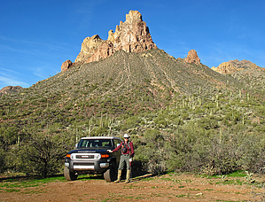
.. Off-Trail Scenic with Navigation Skills .. by Grasshopper  Overview OverviewStarting at 2762 ft this off trail out-n-back route has 4 planned destinations 1) Saddle #1 (3333 ft) 2) Saddle #2 (3405 ft) 3) Saddle #3 (3472 ft) 4) West-High Viewpoint (3500 ft) Warning This entire hike involves off-trail navigation. To understand the terrain before heading out, it is recommended to review triplogs, photos (captions/tag notes, etc.), download, and follow the Official Route, which has "key" navigation waypoints.
Trekking poles are also helpful in navigating the 40% up/down grade before reaching Saddle #1 and help to navigate the sometimes steep traverse off-trail along the backside of Byous Butte from Saddle #2 to Saddle #3. History There are a few old wooden boundary markers held up with rock cairns located along the route to Saddle #1 indicating possible historic mining claim interests. On Saddle #1, there is an old (newly built-up) rock fire ring with older tin cans within the fire ring. Hike & Camping This hike will fool you, appearing short in the total distance at ~2 miles roundtrip, but it takes a while to complete with view stops, navigating, lunch, to reach Saddle #3 West-High Viewpoint (at 3500 ft) and then return to Park/TH Start. For Hike and Camping details, this author recommends viewing his well captioned 2018-01-17 Photoset with A/R tag notes which details this entire hike. Synopsis The four (4) recommended destinations described in this guide for Byous Butte represents only a small section of off-trail exploring that is possible in this immediate, rugged area. One can plan a very scenic, engaging, and remote off-trail route exploring within the vast Hewitt Ridge area by merely making a Right Turn (instead of a Left Turn) at Saddle #1... Enjoy! Check out the Official Route and Triplogs. Leave No Trace and +Add a Triplog after your hike to support this local community. | |||||||||||||||||||||||||||||||||||||||||||||||||||||||||||||||||||||||||||||||||||||||||||||||||||||||||||||||||||||||||||||||||||||||||||||||||||||||||||||||||||||||||||||||||||||||||||||||||||||||||
 Route Editor


