Route Editor

| Guide | ♦ | 31 Triplogs | 3 Topics |
details | drive | no permit | forecast | 🔥 route |
stats |
photos | triplogs | topics | location |
| 403 | 31 | 3 |
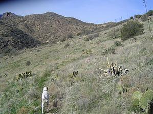
Open Vistas by Fritzski   The JF Trail #106 travels north/south through the central Superstition Wilderness from boundary to boundary. Looking at the topo map it is easy to see that it generally follows one of the few paths of minimal resistance through the range. For this reason, you won't see much extreme terrain, but on the other hand, the hiking is relatively casual with open vistas. The JF Trail #106 travels north/south through the central Superstition Wilderness from boundary to boundary. Looking at the topo map it is easy to see that it generally follows one of the few paths of minimal resistance through the range. For this reason, you won't see much extreme terrain, but on the other hand, the hiking is relatively casual with open vistas.The trail is named after a legendary rancher Jack Frasier. He ran cattle throughout this area from his main ranch at the south end of the trail since the 1890s. The ranch has changed hands many times over the years but is still an active grazing area today. Seeing the mild terrain (by Superstition standards) this trail transits, it's not hard to imagine the trail being a regular thoroughfare for horseback ranchers at one time.
From the parking area at the trailhead proceed south through the fence on the signed JF Trail #106. At about 1/4 miles you'll pass through the Wilderness Area boundary fence. Continue through open terrain and begin the gradual climb past the relics of the old Miller mines on your left and past the Hoolie Bacon Trail intersection at about 2/3mi. Continue straight or left on the JF. Approaching the 2mi point you'll pass the site of the Lost Dutchman Jr Mine on your right. For more info on this story, read Lost Dutchman Mine Junior. From here the terrain begins to get a bit rockier and a few trees begin to dot the landscape. Approaching the 3mi point you'll cross a drainage just downstream of Clover Spring. The stream had a very healthy flow from recent rains. From here continue back up to the top of the ridge through more rocky terrain. The trail follows the ridgeline to about the 4mi point where it drops along the west slope through a nice grassy area. Climb back up to a saddle at the 5mi point and then finally down into the Tortilla Creek bed. This section of the trail gets a bit rugged and bushy in spots, but nothing abusive at all. The trail finally meets the creek bed at about 5.5mi and follows it up and east to the Rogers Canyon Trail intersection on top of Tortilla Pass at 6mi. This is a nice spot for a break and from here you can either return or continue south on the JF Trail to its southern terminus at the Woodbury Trailhead. Not a very spectacular hike, but solitude is almost a guarantee. Long pants are a definite recommendation. This general area seems to be the Cat Claw spawning ground of the Superstitions, and while the trail isn't really overgrown, an army of blood-thirsty "grabbers and stabbers' lurk trailside in wait of the careless. Interesting note: this entire hike is basically a matter of following the Tortilla Creek from its end to its very beginning. On the drive up you cross it as it goes over the road in Tortilla Flat where it empties into Canyon Lake. From there you parallel it along the highway to the FR213 turnoff and then continue to follow it up to the ranch. The hike itself then continues to parallel it and finally meet its headwaters at Tortilla Pass. Check out the Official Route and Triplogs. Leave No Trace and +Add a Triplog after your hike to support this local community. | |||||||||||||||||||||||||||||||||||||||||||||||||||||||||||||||||||||||||||||||||||||||||||||||||||||||||||||||||||||||||||||||||||||||||||||||||||||||||||||||||||||||||||||||||||||||||||||||||||||||