 Route Editor

| Guide | ♦ | 3 Triplogs | 0 Topics |
details | drive | permit | forecast | map |
stats |
photos | triplogs | topics | location |
| 130 | 3 | 0 |
Challenging loop in a remote area by RedRoxx44  Warning! Warning!Check access for AZ Game and Fish Unit 32. Currently, it is listed as having no public access. 2012-03-24 The loop has been well cairned. The difficult part of the West Divide has received trail maintenance. It has been cairned and brush removed. Some of the terrain makes the trail still difficult to see. Follow the cairns and there should be no issues.
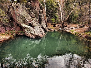
Caution: The Galiuros are isolated and receive little visitation throughout the year. Almost all trailheads require at least a 2wd HC vehicle and are dirt. There is no public access; you must cross private inholdings to reach the trailheads. If you get into trouble in here you are on your own. Help will be slow and a long time coming, even if you have a cell or satellite phone. I recommend TOPO and GPS here, especially if your first time visiting. Day1 - An early start after a night in Willcox--closer for those out of Tucson. From Phoenix, it's easier to stage out of Safford. The road to Rattlesnake Mesa was in good shape; I signed in for the free ranch pass to cross the private land. You display a tag at all times on your vehicle. To drive to Powers Hill you need a good 4wd vehicle. The mesa top is ok for 2wd HC. I loaded up and started down the old wagon road built by the Powers'--very steep and no doubt they had to lock the wagon wheels going down this thing. It's short and you head up heavily wooded Rattlesnake canyon on a good use trail kept clear by horse packers. The canyons here have large ponderosa pine, oak, pinyon-juniper, pockets of maple, and large sycamores. In a mile Rattlesnake turns south in a thick willow choked area--look for the sign announcing Pipestem canyon. I followed this long beautiful canyon to its' head - about 4.5 miles, the trail fading in and out, passing some beautiful green pools in pink slick rock bowls. At the top it's confusing with cairns and use trails; after looking at my map, I chose one that climbed and bent slightly back the way I had come but got me on top of the ridgeline, to pick up the West Divide trail. At the saddle, there are great views out on the San Pedro River Valley. No sign here, an old one down with some faint illegible writing. Casting about revealed a faint trail running south out of the saddle. It becomes better defined and climbs steadily. At times very well behaved, at times downed vegetation et al leads to some bushwacking. The trail comes out to viewpoints along the way that are spectacular, then you have to locate the trail again. Not the fastest hiking in here. There is no water along the ridgeline, Pipestem and Rattlesnake had some running water, usually, these canyons are dry. There are a couple of dams along Pipestem that might hold water for a while, and a signed spring in a side canyon about midway. Past 7000+ Rhodes peak, the West Divide trail disappears. There are some rock cairns, then the terrain makes the trail finding almost impossible. I bushwacked over a couple of 6000+ peaks as indicated where the trail would be on the map; some advice here-- stay high, even though the topo indicates the trail is on a sidehill to the peaks. The slopes are very steep and brushy. At a saddle I made camp, the weather coming in and I had a bit of a water problem. I had great views but no idea if I was on or near the trail. I estimate 9-10 miles this day, and some slow route-finding and challenging bushwacking. Good Aspects-- varying terrain, wonderful views. Bad Aspects- poor trail condition, unless in a rainy season, lack of water. Day 2 - I locate a trail off the saddle--by just observation and luck. Follow it a short distance to a spur trail I believe was the south fork of Field Canyon, and down that to filter some water. Back up on the brushy, at times a deer path, trail eventually to a sign indicating the West Divide, distance to Grassy Ridge, Powers Garden. Lots of ups and downs on the trail cutting along sidehills, crossing heavily wooded drainages. Along one ridgeline as you approach Grassy Peak it narrows down to 20 feet or so and the views into the Galiuro interior and San Pedro River Valley are amazing. Descending Grassy Ridge was nice for me as I knew most of the landmarks in front of me-- Kielberg canyon, the red cliffs near mine and cabin, the talus slope near Long Tom Mine, the divide. The trail alternates between a fair footpath and the line of least resistance through brush-- no trail maintenance in here-- then deposits you on the Powers Garden trail, signed, the Garden a little less than 5 miles away and the Power mine and cabin .4 miles down the hill filled with catclaw trailside. The cabin is the site of the 1918 shootout that left 4 men dead, spawned the largest manhunt in Arizona history. It was also the first time aircraft was used to assist in fugitive locating, and the Powers' brothers when convicted of murder served the longest sentences in Arizona corrections to this day. Several guide books erroneously note the Garden was the site of the shootout. The Powers' did homestead there but left that area to run their mine. Hiking back to the Garden along Rattlesnake Canyon bottom is the easiest of the trip, the path well beat out, crossing the stream bed a lot which was running in places, easy to keep feet dry with a little rock hopping. Some flood evidence indicates it can really rampage in here. This canyon has huge pines and sycamores. At Powers Garden located in a beautiful meadow, camp spots abound. Normally the creek bed is dry here, if so the spring is located a short walk on an obvious use path up the canyon past the corrals, and is reliable. Three cabins are here, the one is available to stay in if you don't mind the usual critters at night, mice, rats, and a ringtail or two. Be sure and tree your food in these mountains as black bears are active, you will usually see their scat along the trails. Day 3 - Short 4 miles out to Powers Hill and the vehicle. From Powers Garden, you also pick up the Tortilla trail out to the Deer Creek trailhead about 8.7 miles away. A nice hike also. Plan your drive out from Powers Hill, it's long and slow so add that time in. By TOPO a little over 25 miles and about 6000 feet gain and 6000 loss on elevation. Total backpack review--Awesome, saw no one the entire trip, great scenery, history, outdoor mining museum, huge old trees, running water, challenging hiking, an excellent trip with an adrenaline edge to it. For experienced backpackers only. Check out the Triplogs. Leave No Trace and +Add a Triplog after your hike to support this local community. One-Way Notice This hike is listed as One-Way. When hiking several trails on a single "hike", log it with a generic name that describes the hike. Then link the trails traveled, check out the example. | |||||||||||||||||||||||||||||||||||||||||||||||||||||||||||||||||||||||||||||||||||||||||||


