Route Editor

| Guide | ♦ | 12 Triplogs | 0 Topics |
details | drive | permit | forecast | map |
stats |
photos | triplogs | topics | location |
| 9 | 12 | 0 |
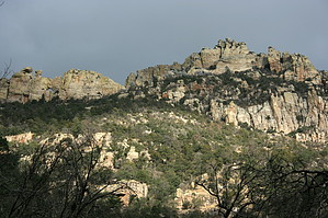
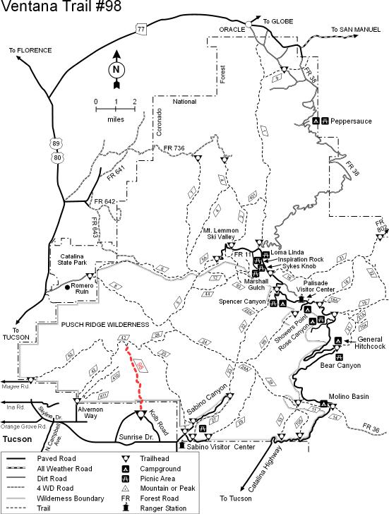
lonely canyon by Lizard  Ventana Canyon is one of the most visited places in the Catalinas next to Sabino Canyon. On a weekend during the cool seasons, you will run into dozens of groups here. And it's easy to figure out why it's so popular; the canyon closes up just a short distance from the trailhead, and you get a great feeling of wilderness, just a few minutes drive from the city. For those who are more adventurous and would like to skip the crowds, it's possible to venture off the trail and do a bit of canyoneering in this wild and scenic place. Ventana Canyon is one of the most visited places in the Catalinas next to Sabino Canyon. On a weekend during the cool seasons, you will run into dozens of groups here. And it's easy to figure out why it's so popular; the canyon closes up just a short distance from the trailhead, and you get a great feeling of wilderness, just a few minutes drive from the city. For those who are more adventurous and would like to skip the crowds, it's possible to venture off the trail and do a bit of canyoneering in this wild and scenic place.From the trailhead, you'll start following the Ventana Canyon trail. The first mile of this trail is routed through private property and is fairly unscenic, bounded on both sides by barbed wire and dozens of no trespassing signs. After an easy mile of hiking, you pass through a gate and into the Pusch Ridge wilderness.
About 1.75 miles from the trailhead, the Ventana Canyon trail departs from Ventana Canyon up a side canyon to the west. Stick to the bed of Ventana Canyon, as the fun stuff is about to begin. As you head up Ventana Canyon, you will have to scramble over some large boulders choking the streambed. Your reward for your effort is a long stretch of granite slickrock, interspersed with occasional waterfalls. You must scramble around these waterfalls- this is the section that may be impassable if the water flow is heavy. Shortly after Ventana Canyon curves around to the west, you'll come to a very short section of narrows. These can be bypassed on the south, but part of the fun is splashing around in them. Just beyond that, you'll reach the base of Ventana Falls. Cowgill and Glendening (the authors of the Tucson hiker's bible, "Guide to the Santa Catalina Mountains") claim that Ventana Falls is the prettiest waterfall in the Catalinas. I would argue that Seven Falls and Seven Cataracts are both nicer, but all the same, it's a very pretty area. The enjoyment is heightened by the knowledge that just over the rise is Maiden Pools. While dozens visit the pools each day, almost no one ventures below them, and you are likely to have this beautiful area all to yourself. Getting past Ventana Falls is the final obstacle of the trip. Pancho Doll claims that a rappel is necessary to access the base of the falls, but I disagree. If you look around the north side of the falls area, you will find a slope that is fairly easily scrambled up. A couple of easy fifth-class climbing moves are necessary. At the top of the falls, take a few minutes to check out Maiden Pools. Once you're ready to move on, look around for the Ventana Canyon trail (it's not hard to find). Take this trail south. It wanders over a large ridge with spectacular views back down over the terrain you came up. The trail eventually empties into a side canyon, and a couple of minutes of walking brings you to the junction of this side canyon with Ventana Canyon. From here, retrace your steps along the trail to the trailhead. Gate Policy: If a gate is closed upon arrival, leave it closed after you go through. If it is open, leave it open. Leaving a closed gate open may put cattle in danger. Closing an open gate may cut them off from water. Please be respectful, leave gates as found. The exception is signage on the gate directing you otherwise.
Check out the Triplogs. Note This is a moderately difficult hike. Leave No Trace and +Add a Triplog after your hike to support this local community. | ||||||||||||||||||||||||||||||||||||||||||||||||||||||||||||||||||||||||||||||||||||||||||||||