 Route Editor

| Guide | ♦ | 524 Triplogs | 0 Topics |
details | drive | no permit | forecast | route |
stats |
photos | triplogs | topics | location |
| 690 | 524 | 0 |
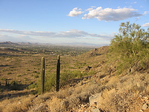
Ridgeless encounters by joebartels  2009 Update 2009 UpdateFormerly know as Quartz Ridge. Hence the title "Ridgeless Encounters" as it doesn't follow a ridge. It's impressive they finally figured it out! Hike This trail takes off south from the 40th Street Trailhead, one mile south of Shea Boulevard at an elevation of 1500 feet. Soon the trail connects with Trail #100 and follows it briefly for a short jag west before heading south again. At 1.25 miles comes a saddle with an elevation of 1776. Here you descend the south side into a ravine. Once down in the ravine, Trail #8A takes off south, instead make a sharp turn north and continue on Trail #8. At this point, you are hiking in the middle of one of the largest cities in the United States with absolutely no sign of the city.
I'm listing this trail one-way as itself. Some may start from the 40th Street Trailhead, come out for the view, and head straight back. However, I doubt it's a popular choice by any means. More likely are a slew of various loops that will only trace sections of this trail. I made a loop of sorts without planning as I just wanted to get to know the area. With a slightly better idea of the area, I think the following would be a decent leisure February spring loop. From the northernmost parking area of Piestewa proper, head out on Trail #302. Connect onto the Perl Charles Memorial Trail #1A and take one of the use trails up to the Charles M. Christiansen Memorial Trail #100, then head back on #8, possibly tagging in the #8A-B variation. Keep in mind there's no ridge hiking involved. The hike consists of a couple of ravines separated by two saddles. Quartz Ridge is what you're going over as described as the first saddle above.
Check out the Official Route and Triplogs. Leave No Trace and +Add a Triplog after your hike to support this local community. One-Way Notice This hike is listed as One-Way. When hiking several trails on a single "hike", log it with a generic name that describes the hike. Then link the trails traveled, check out the example. | |||||||||||||||||||||||||||||||||||||||||||||||||||||||||||||||||||||||||||||||||||||||||||||||||||||||||||||||||||||||||||||||||||||||||||||||||||||||||||||||||||||||||||||||||||||||||||||||||


