Route Editor

| Guide | ♦ | 15 Triplogs | 1 Topic |
details | drive | permit | forecast | map |
stats |
photos | triplogs | topic | location |
| 31 | 15 | 1 |
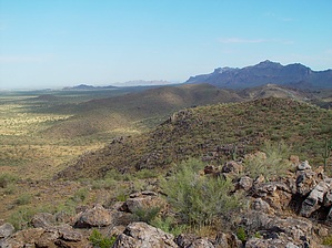
Silent views by joebartels  Black Point Ridge juts northward from West Silver King Road where Whitlow Canyon fades into Queen Creek. Avoid the southern terminus portion of this ridge as it's on grazing and private lands. Black Point Ridge juts northward from West Silver King Road where Whitlow Canyon fades into Queen Creek. Avoid the southern terminus portion of this ridge as it's on grazing and private lands.In various books and articles, I've read over the years the ridge has been lightly mentioned. Most of which are linked to some stone tablet maps presumably found in the area. Many claimed to have found the maps. Most sources credit Travis Tumilinson's claim as he had possession of the maps.
Thomas E. Glover in his 1998 LDM book presents a very good overview of the matter. However, he shows a copy of Travis' personal map depicting the find east of Queen Creek where it crosses US 60 (west of Florence Junction). Fact or fiction it's interesting reading nonetheless. My interest to venture out peaked when I read Garman's book and he mentioned glyphs on Black Point along with Indian grinding holes near the base of the ridge. Simply getting to the ridge proved to be a tad more difficult than anticipated. Eventually, I accessed the ridge from the west on some short steep slopes. It's only 500 feet up. Following the ridge requires minor negotiating with some cliffs, boulders, and such but for the most part, it's easy to travel up top. I'm not listing any route here as I didn't encounter any must-see areas. Depending on where you go your route will likely be somewhere between 1.5 to 5.0 miles. A couple of things to consider if you plan on hiking the area. Long pants or gaiters are recommended as the slopes leading up to the ridge are loaded with bushes and foxtails. The ridge is located on Arizona State Trust Land. You'll need to get a permit way in advance. There's a link in the permits section. You also really need to be able to read a topographical map. If you don't have mapping software you'll need a copy of the 7.5-minute topographical map Florence Junction. Section 34 is not public land except for the upper left & right corners. Section 33 is grazing land. I'd recommend staying in or above sections 28 & 27. This is one of the most peaceful hikes I've been on in a long time. The jagged superstitions outline the northern views. The west is a smooth basin. To the south and east, you get a mix of ridges with Queen Valley, and then there's Picketpost in the distance. I figure most wouldn't enjoy it in 70-degree weather in good health. I went in mid-July in +100 degree temps with a nagging fever. I didn't find any glyphs or grinding holes but I'm pleased to have learned another area! Check out the Triplogs. Leave No Trace and +Add a Triplog after your hike to support this local community. | |||||||||||||||||||||||||||||||||||||||||||||||||||||||||||||||||||||||||||||||||||