Route Editor

| Guide | ♦ | 15 Triplogs | 0 Topics |
details | drive | no permit | forecast | route |
stats |
photos | triplogs | topics | location |
| 393 | 15 | 0 |
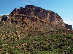
Colinas Gemelo Sonoran Exhale by joebartels  This short yet interesting hike about 11 miles East NE of Florence offers fabulous views. South Butte is one of the two buttes known as the Twin Buttes. The Gila River runs from New Mexico, then west across Arizona to the Colorado River, and cuts right between North and South Buttes. This short yet interesting hike about 11 miles East NE of Florence offers fabulous views. South Butte is one of the two buttes known as the Twin Buttes. The Gila River runs from New Mexico, then west across Arizona to the Colorado River, and cuts right between North and South Buttes.The Gila River most see today is the dry swath they cross on route from Phoenix to Tucson on the I-10 highway. With the reason being, roughly three miles after passing between the Twin Buttes, the Gila River is dammed up and diverted through canals.
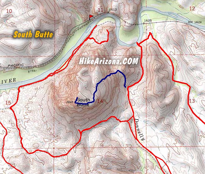
Hike: The hike starts from the east of South Butte. There is a well-defined trail leading up the right side of a ravine formed by a spur fin-like butte to the east of the main butte. See the map or download the GPS route. You should see the trail approaching via Donnelly Wash. It will be pretty obvious where to park and start. Although you won't find the trail immediately, you should be on it after a few minutes at most. It starts somewhat steep on loose terrain but a very well-defined use-trail. Upon reaching the low saddle, head off-trail left. Follow the cairns or easy-to-figure route up the butte. You will need to use your hands in some spots. Nothing is scarry-steep coming up or going down, well, unless you're off course. Be sure to note where you top out on the various layers so you can get back down without confusion. The terrain is interesting. Large plate type rocks are in various piles. Tall grass fills some of the slopes between the cacti. Going into a hike I knew nothing about, I finally lucked out by wearing gaiters. In similar past off-trail outings, I've suffered catclaw butchering and foxtail terror. Albeit hot at 100 degrees in the late-summer afternoon-sun, I was tickled to be hiking nuisance and pain-free! At the top is a monument sized cairn at the edge of the west dropoff. The views are sweet all around. Explore the ridge north for better northern views. Sunrises are fantastic in this area, though I've yet to experience from up top. North views offer the best mid-day photo ops. I can only imagine how stunning sunsets are in the area. This was my third visit this summer alone. The area is interesting to explore from Price to Cochran. Including the Coke Ovens, a railroad, a bridge, a tunnel, the river, and enough uncharted 4x4 routes to keep you busy for days. The butte can be hiked from the north too. Either way, it's not even as steep as Camelback Mountain. However, reaching the north by vehicle requires driving through a five-foot-high tunnel of mesquite and palo verde trees guaranteed to pinstripe your paint. The consequences were obvious, but I couldn't resist the fun!
Check out the Official Route and Triplogs. Leave No Trace and +Add a Triplog after your hike to support this local community. | ||||||||||||||||||||||||||||||||||||||||||||||||||||||||||||||||||||||||||||||||||||||||||||||||||||||||||||||||||||||||||||||||||||||||||||||||||||||||||||||||||||||||||||||||||||||