username
X
password
register
for free!
help


North Butte - Gila River, AZ

Guide 7 Triplogs  0 Topics
  3.7 of 5  
Fav
Wish
1
details
drive
no permit
forecast
route  
stats
photos
triplogs
topics
location
214 7 0
Statistics
tap row or icons for details
Difficulty 3 of 5
Route Finding 4 of 5
Distance Round Trip 2.85 miles
Trailhead Elevation 1,720 feet
Elevation Gain 1,275 feet
Accumulated Gain 1,600 feet
Kokopelli Seeds 10.85
 Interest Off-Trail Hiking & Peak
 Backpack Possible - Not Popular
feature photo
Photos Viewed All MineFollowing
Will recalculate on button tap!
92  2025-01-09 Mike_W
32  2016-02-13
Gila River:Cochran to Tunnel to Dam
topohiker
21  2013-02-23
North Butte-South Butte Loop
The_Eagle
15  2013-02-23
North Butte-South Butte Loop
joebartels
29  2012-11-12 FLYING_FLIVER
25  2005-09-12 joebartels
Author
author avatar Guides 264
Routes 2,797
Photos 14,494
Trips 5,894 map ( 29,783 miles )
Age 55 Male Gender
Location
Associated Areas
list map done
Globe Region
Historical Weather
Trailhead Forecast
Radar Map
Expand Map
Preferred Feb, Jan, Dec, Nov → 8 AM
Seasons   Late Autumn to Early Spring
Sun  6:02am - 6:45pm
Official Route & 2 Rts
 
2 Alternative


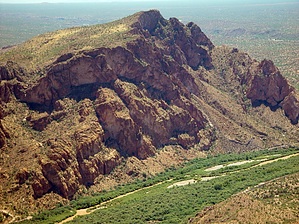
A river runs near it
by joebartels

  
Prologue
Having recently hiked South Butte, it's only natural I wanted to hike North Butte. This butte viewed from South Butte is gorgeous! It's also more eye-pleasing from Florence. Like Sedona and Grand Canyon, it's eroding and seems to have more color and steep terrain variation.


Beauty comes at a price. In which you pay in short steep slopes to near climbing. Nothing is technical. Going up is fun in the fact that there are no trails or even cairns. Route options appear to be plentiful. The only downside is the terrain itself. It's pretty unstable, so be careful. On my late summer trek, the mostly dead vegetation was cranking out micro thorns of some sort. These microneedles are similar to the fine needles on prickly pear cactus. I don't know where they came from but they sure did itch.
remove free decal offer
The top of North Butte consists of three high points. The lowest being on the north to the highest on the south. Most people likely head straight for the southern high point as it's the peak. I headed straight up to the middle-high point. It seemed impossible getting closer but proved to be relatively simple, requiring only minimal hand assist.

Once on top, I took in the views all around. The terrain is small boulders and large plates of rock, many of which are unstable. I didn't venture out to the north edge, but thinking back, it may have offered the best views. I moved on south to the peak. The views were a little disappointing compared to South Butte, but it was hard to complain on such a beautiful day.

South Butte is the best of the two buttes as far as views go. South Butte also has a superior cliff edge. The terrain is easier to negotiate too. However, if you're looking for something a little more challenging off the beaten path, then North Butte is worth a visit. I recommend wearing long pants or gaiters at the least.

2005-09-12 joebartels


    Check out the Official Route and Triplogs.
    Leave No Trace and +Add a Triplog after your hike to support this local community.
    WARNING! Hiking and outdoor related sports can be dangerous. Be responsible and prepare for the trip. Study the area you are entering and plan accordingly. Dress for the current and unexpected weather changes. Take plenty of water. Never go alone. Make an itinerary with your plan(s), route(s), destination(s) and expected return time. Give your itinerary to trusted family and/or friends.

     Permit $$
    None


     Directions
    or
     Road
    High Clearance possible when dry

    To hike
    From Florence
    North on SR79 over the usually dry Gila River. Perhaps within a quarter-mile comes the first right turn. This is E Price Station Road. Take this generally unmarked dirt road east. When the road turns into a sandy wash, you will be heading up N Box Canyon Road. The junction is subtle and unmarked. The trailhead, a cleared swath of desert on your left, is just over 12.2 miles from SR79. There's enough parking for about 10-15 vehicles. The sandy wash, which becomes the road, is too deep for cars. High clearance is probably fine.
     90+° 8am - 6pm kills
    helpcorrectionissue

    end of page marker