Route Editor

| Guide | ♦ | 65 Triplogs | 3 Topics |
details | drive | permit | forecast | 🔥 route |
stats |
photos | triplogs | topics | location |
| 162 | 65 | 3 |
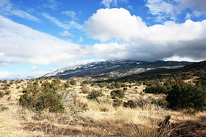
A good day hike by carolynashby   This was my first hike into the Rincon Mountains. We left Phoenix at 6:15am and were on the trail at 8.35am. It was the same day as the Tour of Tucson bike ride and they were setting up checkpoints on our way in however this did not slow us too much. The first 1/2 mile of the trail is fairly typical with several other trails branching off. In our hiking group of 5, we had individuals who were using the hike for different purposes. One of our members took off to run the trail all the way to Cow Head Saddle. 2.5 miles further than the Douglas Springs turnaround I was planning on. He was already heading back to the trailhead before the rest of the group we intersected about a mile before we got to Douglas Springs. This was my first hike into the Rincon Mountains. We left Phoenix at 6:15am and were on the trail at 8.35am. It was the same day as the Tour of Tucson bike ride and they were setting up checkpoints on our way in however this did not slow us too much. The first 1/2 mile of the trail is fairly typical with several other trails branching off. In our hiking group of 5, we had individuals who were using the hike for different purposes. One of our members took off to run the trail all the way to Cow Head Saddle. 2.5 miles further than the Douglas Springs turnaround I was planning on. He was already heading back to the trailhead before the rest of the group we intersected about a mile before we got to Douglas Springs.The Douglas Springs Trail follows the boundary of the Saguaro National Park east pretty much the whole way and the trail elevation increases fairly gradually the whole way so you can make pretty good time. On your way in the trail is carved out of thick grasses however you can't help but notice the change in the surrounding plants with elevation as cacti give way to short junipers. The view on your left (unfortunately) is of encroaching subdivisions neatly drawn out in the distance below, on your right are rolling hills covered with grasses. On the hike, we were passed by at least 4 runners heading back to the trailhead so the footing was pretty solid and I'm guessing the work coming down (all downhill) might make this good running training ground. The views on the way up were nothing spectacular, short rolling hills with the trail winding its way up and around them. You lose the subdivisions after about 4 miles. and given the steady incline, the trail had a very calming feel to it.
The hike down was quick. I did notice several burnt areas that I had not noticed on the way up. The View is also very different as well as on your right there is more of a panoramic wide open area and had a whole different feel, on the way in you felt pretty closed in, and on the way out it really opened up. Of course, this changed as soon as the subdivisions came back into sight.
Check out the Official Route and Triplogs. Leave No Trace and +Add a Triplog after your hike to support this local community. | |||||||||||||||||||||||||||||||||||||||||||||||||||||||||||||||||||||||||||||||||||||||||||||||||||||||||||||||||||||||||||||||||||||||||||||||||||||||||||||||||||||||||||||||||||||||||||||||||||||||||||