username
X
password
register
for free!
help
 
  🔥

Fish Creek Peak, AZ

Guide 7 Triplogs  0 Topics
  3.7 of 5  
Fav
Wish
7
details
drive
no permit
forecast
🔥
route  
stats
photos
triplogs
topics
location
23 7 0
Statistics
tap row or icons for details
Difficulty 4 of 5
Route Finding 3 of 5
Distance Round Trip 3.2 miles
Trailhead Elevation 2,373 feet
Elevation Gain 1,500 feet
Accumulated Gain 2,100 feet
Avg Time Round Trip 5 hours
Kokopelli Seeds 13.7
 Interest Off-Trail Hiking & Peak
 Backpack Possible - Not Popular
feature photo
Photos Viewed All MineFollowing
Will recalculate on button tap!
8  2023-11-15
Black Cross Fishiness
pseudalpine
11  2014-02-22
BCB 4806 - Fish Peak Loop & BCB 3351
joebartels
15  2014-02-22
Black Cross Butte 4806 - Fish Creek Peak Loop
The_Eagle
15  2014-02-22
BCB 4806 - Fish Peak Loop & BCB 3351
johnlp
10  2014-02-22
Black Cross Butte 4806 - Fish Creek Peak Loop
Tortoise_Hiker
11  2011-01-27 AZOutdoorsman
12  2005-12-25 joebartels
Author
author avatar Guides 264
Routes 2,797
Photos 14,494
Trips 5,894 map ( 29,783 miles )
Age 55 Male Gender
Location
Associated Areas
list map done
Phoenix Region
Historical Weather
Trailhead Forecast
Radar Map
Expand Map
Preferred Mar, Nov, Feb, Apr → 8 AM
Seasons   Late Autumn to Early Spring
Sun  6:02am - 6:45pm
Official Route
 
3 Alternative
 
Historic Fire Perimeteracres
🔥 2019 Woodbury Fire123.8k


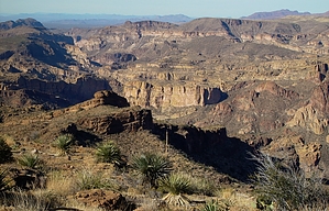
Sassy Desert
by joebartels

 
This off-trail hike follows my Black Cross Butte route to the saddle before making a mean direct approach to Fish Creek Peak.


From the pullout dip through the usually dry creek and head up to the first bench. This ego buster slope starts steep and just gets steeper. The final push-up is a 55-degree huffer. On the bench keep left up to the second bench. Cairns should help lead the way for this next section up to a saddle that's the only real break in the wall looming ahead. If the cairns fail you the key is to aim right or you'll waste time going through vegetation.
remove free decal offer
From the saddle continue down the ravine on the flip side. Stay high on the right bank, there is one section you'll drop down into the ravine for a short distance, but get back out soon or you'll hit vegetation galore. As you approach the apparent confluence you want to get further right and cheat the confluence. Fish Creek Peak is the huge rock-butte looming above. It's easiest to access from the slanting ridge on the right. It is doable from the left but it's not as direct and you're more likely to get frustrated. Here's where it just gets nasty, you have to cross this Amazon-looking forest that lines the ravine. It's at least twenty to fifty yards of hell no matter how you tackle it so just have at it.

You can head pretty much straight up to the peak but the time spent fanning wide to the right is well worth it. Once you get on the ridge follow up to the rock-butte peak. It's easy climbing that spirals the backside (really west side) up to the top.

If you're familiar with upper Fish Creek then that huge wall spanning the west ravine might look a little familiar. There are some fair distant views too, but... Now for the bad news. This isn't the greatest destination. Other hikes such as nearby Black Cross Butte or Bronco Butte have more "breathtaking" views.

Return by the same way but be careful as accidents are prone to happen on the steep loose descents.

2005-12-25 joebartels


    Check out the Official Route and Triplogs.

    Note
    This is a moderately difficult hike.
    Leave No Trace and +Add a Triplog after your hike to support this local community.
    WARNING! Hiking and outdoor related sports can be dangerous. Be responsible and prepare for the trip. Study the area you are entering and plan accordingly. Dress for the current and unexpected weather changes. Take plenty of water. Never go alone. Make an itinerary with your plan(s), route(s), destination(s) and expected return time. Give your itinerary to trusted family and/or friends.

     Permit $$
    None


     Directions
    or
     Road
    FR / Dirt Road / Gravel - Car Okay

    To hike
    From Phoenix take the Apache Trail out past Fish Creek Bridge. Pass two more one-lane bridges and park in the first major pullout on a bend left. Download the GPS route for exact reference.
     90+° 8am - 6pm kills
    helpcorrectionissue

    end of page marker