Hike
From the popular Telegraph Pass Trailhead in Ahwatukee, you ascend Telegraph Pass Trail to the pass in 1.2 mi. This is a shared experience. I call it the housewife express. There's also a good mix of families and occasionally mountain bikers on each trip.
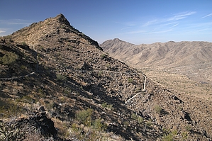
Then it's left following the National Trail. Here you lose about ninety percent of the crowd. Follow the road left until you come to the guard rail. At which point you'll see the trail pick up again. Soon you hit the switchbacks and work up to the ridge. In another 0.7 mi, at the lofty perch on the National segment, you'll typically lose all followers.
Continuing on you follow a sweet ridge 1.0 mi over to Goat Hill. It's rare to encounter others on this stretch out of season. This is the finest inner city ridge. It takes you past the Ranger Trail junction and onto Goat Hill. Goat Hill is the tallest, furthest, and westernmost peak of the mini Four Peaks formation. Return by the same route.
Late Spring Journey - Early April
Spring continues its cycle, Creosote Bush is in full bloom. Avoid contact as it dyes a saturated yellow swath upon brushing.
Brittlebush has turned to tambourines in the wind. Skeletons of fiddlenecks stand as fuel. At which, even the lightest brush will torture you worse than a foxtail ever imagined. Scorpionweed resembles an ornament of exposure. Ironwoods droop in glee. Saguaros laugh in anticipation as round one of summer nears. In the Valley of the Sun autumn passes the baton to spring. Winter is skipped and summer extreme is the result.
Past the populated ascent and onto the ridge you enter the Summer of '42. Hillsides are a canvas of subtle hues. Bone dry wildflowers crack in the last gasp of spring. Albeit sad this is life in the purest sense. Few will ever understand for Arizona isn't a destination, it's an experience.
WARNING! Hiking and outdoor related sports can be dangerous. Be responsible and prepare for the trip. Study the area you are entering and plan accordingly. Dress for the current and unexpected weather changes. Take plenty of water. Never go alone. Make an itinerary with your plan(s), route(s), destination(s) and expected return time. Give your itinerary to trusted family and/or friends.
Permit $$
None
Directions
Road
Paved - Car Okay
To Telegraph Pass Trailhead From I-10 take Chandler Boulevard 4.8mi west to Desert Foothills Parkway. Turn right and follow 1.3mi. The parkway curves west. It's easy to find.
Quicker: Alternate route: From I-10 and the Loop 202 take Pecos Road west, which is a westward extension of the 202. Go 5 miles to Desert Foothills Parkway. Take a right going north on DFP for 2.5 miles to the trailhead on the right side of the road.
From PHX (I-10 & AZ-51) 19.4 mi - about 30 mins From TUC (Jct 1-10 & Grant) 102 mi - about 1 hour 36 mins From FLG (Jct I-17 & I-40) 163 mi - about 2 hours 37 mins
 Route Editor

 Hike
Hike