Route Editor

| Guide | ♦ | 13 Triplogs | 1 Topic |
details | drive | no permit | forecast | route |
stats |
photos | triplogs | topic | location |
| 41 | 13 | 1 |
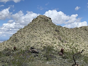
Nice hill, but not the GOAT... by John10s  Overview OverviewGoat Hill (2,526') is the high point in the Gila Range of South Mountain and the second-highest peak among the three ranges that make up South Mountain, behind Mt. Suppoa (2,690'). Of the five different guides that lead to Goat Hill listed on HAZ as of this writing, this option is the longest, coming in at just under 20 miles as an out-and-back hike on National Trail from Pima Canyon Trailhead. Hike Starting from Pima Canyon TH, the first 1.3 miles of National Trail consist of a relatively flat fire road, then National begins to steadily gain elevation past the intersection with Mormon Loop Trail. Around 2.5 miles into the hike, you'll reach the intersection with Hidden Valley Trail. If you're looking for a short, scenic detour off of National that doesn't significantly change the overall length of the hike, you can take the left turn and visit Hidden Valley Tunnel and Fat Man's Pass before reconnecting with National Trail after a little more than a half mile.
Telegraph Pass and the lookout structure soon come into view, and after descending a few switchbacks, you'll reach the intersection with Telegraph Pass Trail and begin a short, steep climb up past the stone structure, re-gaining ~400' of elevation over three-quarters of a mile. You'll pass the intersection with Pyramid Trail at ~8.5 miles into the hike, with improving views of the Ma Ha Tauk range to the northwest and the rocky ridgeline where Goat Hill is located. Just under a mile further, you'll reach the intersection with Ranger Trail, and National becomes narrower and drops off steeply on the side as it skirts the south side of the ridge. Goat Hill is located on the west end of the ridge; look for an obvious but unsigned use trail that turns off National Trail and follow this a short distance up the switchbacks to the top. From Goat Hill, you'll have unobstructed 360° views. Back to the east from the direction you came from, you'll see Telegraph Pass and the radio towers on Mt. Suppoa. The Sierra Estrellas dominate the western horizon, and to the north, depending on the amount of haze, visible landmarks include downtown Phoenix, Camelback Mountain, Piestewa Peak, and Mummy Mountain. Down below to the northwest, you'll see Alta Trailhead, and beyond it the Ma Ha Tauk Range and Maricopa Peak. Looking south/southwest, the continuation of the National Trail and the city of Ahwatukee are visible. Once you've enjoyed the views, you can return to Pima Canyon TH via the same route back along National Trail or, given the extensive network of trails at South Mountain, extended the outing with countless other options. Check out the Official Route and Triplogs. Leave No Trace and +Add a Triplog after your hike to support this local community. | |||||||||||||||||||||||||||||||||||||||||||||||||||||||||||||||||||||||||||