Route Editor

| Guide | ♦ | 216 Triplogs | 0 Topics |
details | drive | no permit | forecast | route |
stats |
photos | triplogs | topics | location |
| 331 | 216 | 0 |
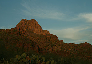
gaze off into the foothills by fricknaley  Safford Peak as it is officially known (Sombrero Peak to us Tucson locals) is that distinctive bell-shaped peak in the northern-most district of the Tucson Mountains in Saguaro West National Park. No doubt you've seen it when passing through northern Tucson. I see it every day because I live right beneath it and I always consider myself lucky as I look at it driving home. As it turns out, it is also an absolute blast to climb. Safford Peak as it is officially known (Sombrero Peak to us Tucson locals) is that distinctive bell-shaped peak in the northern-most district of the Tucson Mountains in Saguaro West National Park. No doubt you've seen it when passing through northern Tucson. I see it every day because I live right beneath it and I always consider myself lucky as I look at it driving home. As it turns out, it is also an absolute blast to climb.There is no official trail here but there is pretty much something to follow the whole way. Nonetheless decent route finding skills will come in handy. There are multiple ways to get to the trail that begins the ascent to the peak. I will describe from a quiet little chapel called Sanctuary Cove as this is the easiest to find. There are numerous miles of foot trails and horse trails in the basin surrounding the peak, and you could add any distance you want to get to the trail that starts the climb.
I counted three saddles that you will ascend in relatively short order as you climb east and slightly north up the peak. At each saddle take a left at the fork in the trail. I placed cairns at each intersection, so hopefully, that will help. As you climb the views open up fast. After the 2nd saddle, you will realize that you are heading towards the northern face of the peak and that this face is purely vertical. Panther Peak will pop up and make itself known as well. As you reach the 3rd small saddle the vertical north face will be in front of and to the left of you. This is where you will take your third consecutive left (hopefully will still be cairned). Look for little faint paths heading up and to your left, for the key is to now head south to get to the accessible east face of the peak. Whichever faint path you take, it does not matter as long as you are climbing and heading south they kind of all seem to merge again shortly. After you have worked your way back to the west then the southwest face of the peak, the trail picks up again and becomes easy to follow. It winds and climbs around the southern then southeastern flank of the peak. The views are now excellent as you gaze off into the foothills and higher peaks of the Tucson Mountains and Saguaro National Park...very nice. Ultimately, the trail will start to climb severely and make the push to the summit via an eastern approach. The trail is very faint here, but I was still able to follow it easily enough. By now you can see where you are going anyway. The last stretch is pure rock climbing, with some narrow traverses with significant exposure. If you don't like exposed heights, I would not recommend this hike. The summit offers great views in all directions. There is a register as well. Follow back the way you came, the best you can anyhow. Please do not attempt this hike in the summer, as it is purely exposed the whole way. Also if you don't like heights (especially with exposure) you might not like this one. Otherwise, have fun, this hike is really cool and pretty challenging for the distance.
Check out the Official Route and Triplogs. Leave No Trace and +Add a Triplog after your hike to support this local community. | |||||||||||||||||||||||||||||||||||||||||||||||||||||||||||||||||||||||||||||||||||||