username
X
password
register
for free!
help
  
  🔥

Tortilla - Fish Mesa, AZ

Guide 19 Triplogs  0 Topics
  3.8 of 5  
Fav
Wish
4
details
drive
no permit
forecast
🔥
route  
stats
photos
triplogs
topics
location
150 19 0
Statistics
tap row or icons for details
Difficulty 2.5 of 5
Route Finding 3 of 5
Distance Loop 5.75 miles
Trailhead Elevation 2,871 feet
Elevation Gain 914 feet
Accumulated Gain 1,490 feet
Avg Time Round Trip 4-5 hours
Kokopelli Seeds 13.2
 Interest Off-Trail Hiking & Peak
 Backpack Possible - Not Popular
feature photo
Photos Viewed All MineFollowing
Inaugural Calculation on Button Tap!
44  2025-04-19
Tortilla Mountain - Superstition Wilderness
chumley
45  2025-04-19
Tortilla Mountain - Superstition Wilderness
John10s
5  2024-02-04
Fish Taco with Bacon
pseudalpine
36  2023-12-02 John10s
15  2023-11-29 rayhuston
5  2023-08-04 pseudalpine
13  2018-01-26 jameslcox44
8  2015-11-14
Tortilla-Fish Mesa - Fish Creek Canyon Loop
joebartels
Page 1,  2
Author
author avatar Guides 264
Routes 2,797
Photos 14,494
Trips 5,894 map ( 29,783 miles )
Age 55 Male Gender
Location
Associated Areas
list map done
Phoenix Region
Historical Weather
Trailhead Forecast
Radar Map
Expand Map
Preferred Mar, Nov, Feb, Jan → 8 AM
Seasons   Autumn to Early Spring
Sun  6:02am - 6:46pm
Official Route & 4 Rts
 
6 Alternative
 
Historic Fire Perimetersacres
🔥 2019 Woodbury Fire123.8k
🔥 2011 Tortilla Fire10.5 mi*
🔥 View (All) - over Official Route 🔥
*perimeter length in miles


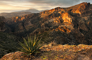
Off trail in the wine sipping sense
by joebartels

  
Overview
This easy to moderate off-trail hike spans a mesa that separates Tortilla Creek from Fish Creek. It's presented here as a loop hike starting 0.8 miles into FR 213. The hike crosses the mesa, drops down near Tortilla Trailhead, then follows FR 213 back.


Hike
Head out straight east until you drop down and hit a dense foliage ravine. Scroll to your right until you find the least path of resistance across the ravine. Or bush-push your way across as I did. Once across you simply head southeast to Peak 3785 across the mesa. It takes some minor effort to get up on the mesa. Then it's a gentle rise across. The going is simple but pay attention or you'll be wrestling cacti along the way.
remove free decal offer
Better views favor the Fish Creek edge. Optimum photo ops are likely in the late-day fading sun. I roamed the area in mid-day light on an overcast day with off-n-on lite sprinkles. One of the better views of Black Cross Butte is from this western vantage point. The main focal draw is down Fish Creek with distant views of the Four Peaks and Bronco Butte. This isn't an eye-popping experience like Coronado Mesa. On the other hand, it's a better hike with lots of roaming possibilities. The area doesn't show many obvious signs of previous travel. All the use trails I crossed are certainly wildlife created as they dodge under ocotillo and such.

Peak 3785 is the high point on this mesa / wide-ridge. It's not marked on the USGS topographical map but there is a brass cap and a large cairn. You should be able to make out the water tower at Tortilla Trailhead down to your west-southwest. Find a good route down then take the road back. I headed pretty much west and down and encountered typical catclaw for the Tortilla area. You might have better odds continuing south to Hoolie before swinging west.

2006-03-08 joebartels


    Check out the Official Route and Triplogs.
    Leave No Trace and +Add a Triplog after your hike to support this local community.
    WARNING! Hiking and outdoor related sports can be dangerous. Be responsible and prepare for the trip. Study the area you are entering and plan accordingly. Dress for the current and unexpected weather changes. Take plenty of water. Never go alone. Make an itinerary with your plan(s), route(s), destination(s) and expected return time. Give your itinerary to trusted family and/or friends.

     Permit $$
    None


     Directions
    or
     Road
    Strictly 4x4

    To hike
    From Apache Junction head out on SR88. For reference, the First Water Trailhead turnoff is just after mile marker 201. You need continue out past Canyon Lake and past Tortilla Flats to the end of the pavement. Continue on the dirt road about 0.8 miles to mile marker 221. There's a good size sign with an arrow for Tortilla Trailhead. This is FS213, take it 0.8 miles and park. You should be situated on a ridge that extends to Peak 3141.
     90+° 8am - 6pm kills
    helpcorrectionissue

    end of page marker