Route Editor

| Guide | ♦ | 42 Triplogs | 0 Topics |
details | drive | permit | forecast | 🔥 route |
stats |
photos | triplogs | topics | location |
| 163 | 42 | 0 |
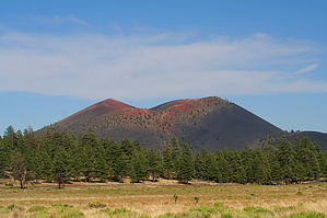
One foot up... two back by PaleoRob   Lenox Crater Trail, in Sunset Crater National Monument, is a short trail that leads to the top of an extinct cinder cone-type volcano, named (surprise) Lenox Crater. Lenox Crater Trail, in Sunset Crater National Monument, is a short trail that leads to the top of an extinct cinder cone-type volcano, named (surprise) Lenox Crater.The hike is fairly straightforward - the parking lot for the trail is signed, and is also a pullout for the Bonito Flow in SCNM, along the main road. After crossing the road, the trail strikes out up the cinder cone. For those that have hiked cinder cones, like SP, before, the experience doesn't change much here. The trail is marked, but not improved over the native cinders. It's tough going for those not used to 7,000 feet or hiking on cinders. Looks can be deceiving - the crater doesn't look that tall (and it isn't), but it can take up to 1/2 an hour to reach the summit, where an interpretive sign discusses the view to the west of the Cinder Hills and the San Francisco Peaks. This probably isn't a good hike for those that have breathing troubles. I did this trail when I was 19, and it winded me by the top (but I wasn't as serious of a hiker either).
Check out the Official Route and Triplogs. Leave No Trace and +Add a Triplog after your hike to support this local community. | |||||||||||||||||||||||||||||||||||||||||||||||||||||||||||||||||||||||||||||||||||||||||||||||||||||||||||||||||||