Route Editor

| Guide | ♦ | 4 Triplogs | 0 Topics |
details | drive | permit | forecast | map |
stats |
photos | triplogs | topics | location |
| 10 | 4 | 0 |
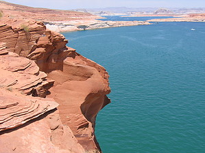
  There is no trail here on the western bank of Glen Canyon at Wahweap Bay and the distance and elevation gains are educated guesses. And who cares, because this is a free-for-all scramble along the cliffs overlooking Lake Powell down to a secluded little peninsula beach. What a treat! There is no trail here on the western bank of Glen Canyon at Wahweap Bay and the distance and elevation gains are educated guesses. And who cares, because this is a free-for-all scramble along the cliffs overlooking Lake Powell down to a secluded little peninsula beach. What a treat!Scramble down the escarpment from the parking area and immediately start playing among the formations and waterfolds. Within minutes you will be standing at the ledge of the cliffs overlooking Lake Powell. The Glen Canyon Dam is to your right. There are amazing sandstone formations off in the distance, and a large part of Lake Powell and Wahweap Bay are to your left. Head out that way, playing along the crazy ledges and enjoying the formations as you go. You will see an isolated little peninsula jutting out into the water about 1 to 1.5 miles down. I just scrambled along aiming for this. A little over halfway, the going becomes too steep to travel along briefly and I scrambled up the ridge to the road... WOW, sandstone gets hot. After a very brief jaunt along the road, it was right back down a small gulley and into the formations again.
When you are ready, head up back towards the road, climbing up the ridge. I crossed immediately over the road and climbed up the ridge on the other side. The plan is to hike the ridgeline of buttes and formations back to the car. The sandstone here allows you to climb and walk up at impossible angles because it is so sticky. This must be what a mountain goat or bighorn sheep feels like as they walk up seemingly vertical angles. Good stuff. There is any number of ledges, tables, folds, and everything else up along this ridge. Pick your way. Soon you will see your parking spot. Pick a spot, climb down and walk the short distance back to your car. Plan on getting wet on this one, if you want. Considering the exposure along the way, it's the highlight of the walk. I'm giving PageRob co-authorship of this hike because it was his suggestion to go exploring here... Thanks, Rob. Check out the Triplogs. Leave No Trace and +Add a Triplog after your hike to support this local community. | |||||||||||||||||||||||||||||||||||||||||||||||||||||||||||||||||||||||||||||||||||||