 Route Editor

| Guide | ♦ | 15 Triplogs | 1 Topic |
details | drive | permit | forecast | 🔥 route |
stats |
photos | triplogs | topic | location |
| 435 | 15 | 1 |
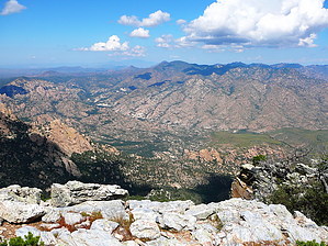
Get ready for trail finding! by RedRoxx44   2020 Note 2020 NoteRoute and conditions have changed over the years. Check triplogs for current known conditions. The Santa Teresa Mountains rise in a sort of triangle with the Pinalenos and the Galiuros. It is a rough and wild area. Trails are minimal and mostly pack stock trails. The trail to Cottonwood Mountain, the high point of the Santa Teresas at a little over 7000 feet, is off an established stock route. However, as in most things, would it be so simple if the trail was not as severely deteriorated as this one.
You will pass through three gates, and please close them. I camped before the final gate, which shows use of a quad trail in a riparian area. You will follow the vehicle tracks in the wash, by a lovely grove of Arizona Sycamores, by a huge lone cottonwood tree. Usually, this is a dry wash, but a little water was flowing while I was here. At this point, you better have a map with you and a compass or GPS. Looking up, you will see the jagged rock teeth of Pinnacle Ridge and the rounded humps of the mountains above. The highest gentle curve is Cottonwood mountain, and it is not clear how you will broach the ascent. The trail I found was about 15% easily followed, and for the rest, you have to look for it, pay close attention to any faint path, and use your map. I never found one area where the trail leaves cottonwood wash; I continued upcanyon and climbed out after it slotted up and no horse or cow could easily climb the rocky narrows. I intersected the trail on its climb north up the hill. Soon you come to switchbacks and big views opening up. The switchbacks and part of the trail are cairned, but at times the trail behaves somewhat strangely. Brush from all the rains made it a real challenge to follow. Persevere, you will climb laterally to a small pass located to the north. The slopes you have been on have been burned in the past and show high desert flora. After you top out at the saddle, some tall pines and grassy areas greet you. Fantastic views of the inner mountains are had near several rock outcroppings nearby. One rock shelf is incredibly level and would make an excellent campsite. Amazing rock monoliths abound. Some voids in the rocks are small alcoves. There is a faint use trail to cottonwood mountain, and you can also continue along the ridgeline for a while. When you retrace your route, pay close attention to the trail, as it is still not clear in areas the right way to go. If you get to the wash and follow that, you will get to the road and your vehicle. Gate Policy: If a gate is closed upon arrival, leave it closed after you go through. If it is open, leave it open. Leaving a closed gate open may put cattle in danger. Closing an open gate may cut them off from water. Please be respectful, leave gates as found. The exception is signage on the gate directing you otherwise. Check out the Official Route and Triplogs. Leave No Trace and +Add a Triplog after your hike to support this local community. One-Way Notice This hike is listed as One-Way. When hiking several trails on a single "hike", log it with a generic name that describes the hike. Then link the trails traveled, check out the example. | |||||||||||||||||||||||||||||||||||||||||||||||||||||||||||||||||||||||||||||||||||||||||||||||||||||||||||||||||||||||||||||||||||||||||||||||||||||||||||||||||||||||||||||||||||||||||||||||||||


