Route Editor

| Guide | ♦ | 39 Triplogs | 0 Topics |
details | drive | permit | forecast | 🔥 route |
stats |
photos | triplogs | topics | location |
| 465 | 39 | 0 |
Canyons are inherently risky. Flash floods occur without notice on sunny days. Technical skills & surrounding topography knowledge required yet does not eliminate risk.
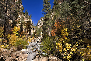
Gnarly! by joebartels  Pumphouse Wash is the headwaters of Oak Creek. The canyon I describe spans 4 miles from FR 237 to the Pumphouse bridge on 89A. Kelly Canyon enters from the east near the top of Pumphouse Wash. James Canyon also comes from the east at the halfway point. James Canyon captures water from an area around and across I-17 that you have likely driven over without knowing. Packed with narrows, pools, and several waterfalls, James Canyon is fantastic but not really in the day-hike category. The upper section of Pumphouse from James Canyon to FR 237 is a broad, shallow course. From James Canyon down to the Pumphouse bridge, the canyon is narrow and much higher. Therefore I have split Pumphouse Wash into upper and lower descriptions. Pumphouse Wash is the headwaters of Oak Creek. The canyon I describe spans 4 miles from FR 237 to the Pumphouse bridge on 89A. Kelly Canyon enters from the east near the top of Pumphouse Wash. James Canyon also comes from the east at the halfway point. James Canyon captures water from an area around and across I-17 that you have likely driven over without knowing. Packed with narrows, pools, and several waterfalls, James Canyon is fantastic but not really in the day-hike category. The upper section of Pumphouse from James Canyon to FR 237 is a broad, shallow course. From James Canyon down to the Pumphouse bridge, the canyon is narrow and much higher. Therefore I have split Pumphouse Wash into upper and lower descriptions.From the parking area, head down the steep slope into the canyon. I made it down without issue. The gal behind me slid down on her butt. Once in the wash, head back under the bridge and up the canyon. The wash is rocky with mid-size boulders from the beginning. Please note this is not an area to be exploring with rain in the forecast. You will find yourself a river ornament if you choose unwisely.
I passed several trees wedged in-between the canyon walls. Hopefully, this should forewarn those planning a rainy day hike. If it's raining to the north or east, you're in trouble. It doesn't have to be raining in the canyon for a flash flood to occur. A short steep canyon enters from the east near the 1.5-mile mark. Continue up to the larger and broader canyon coming in from the east, which is James Canyon. Here I opt to turn around. Continuing up Pumphouse Canyon requires negotiating a 14-foot fall. The only means of getting around is a steep scramble route to the right. It's easier getting up than down, in my opinion, so keep that in mind. You can also head on up James Canyon, which is fantastic. However, you'll probably get into more than expected.
Check out the Official Route and Triplogs. Leave No Trace and +Add a Triplog after your canyon trip to support this local community. | |||||||||||||||||||||||||||||||||||||||||||||||||||||||||||||||||||||||||||||||||||||||||||||||||||||||||