Route Editor

| Guide | ♦ | 5 Triplogs | 0 Topics |
details | drive | permit | forecast | map |
stats |
photos | triplogs | topics | location |
| 20 | 5 | 0 |
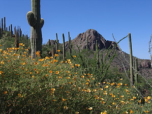
Mountain Lions in my Backyard? by fricknaley  Unless you see it from the correct vantage, you would never know that there is a rugged and relatively wild canyon cutting between Safford Peak and Panther Peak to the north and Peak 3262 (the broad flat table-top like peak) to the south in the Northern District of Saguaro West National Park. The best place to see it is actually from the south side of Sombrero Peak. It got me curious, so I decided to check it out. I wanted to use this canyon to access the broad, flat Peak 3263 that is such a landmark here in northern Tucson. Unless you see it from the correct vantage, you would never know that there is a rugged and relatively wild canyon cutting between Safford Peak and Panther Peak to the north and Peak 3262 (the broad flat table-top like peak) to the south in the Northern District of Saguaro West National Park. The best place to see it is actually from the south side of Sombrero Peak. It got me curious, so I decided to check it out. I wanted to use this canyon to access the broad, flat Peak 3263 that is such a landmark here in northern Tucson.To get there, take off from Sanctuary Cove. I have described this under the guide for Safford Peak. Follow the same route, continuing past the right turn off to Sombrero. Keep going along the desert terrain, enjoying the huge Saguaro and Barrels. In about 1.2 miles, there is a well-defined split in the trail to the right. Take this. It starts as kind of an old jeep track, then disintegrates into vagueness. You can begin to see Safford Canyon now. It's not named Safford Canyon. That's just what I call it. I called the Park Service to ask it, or Peak 3263 had a real name, and neither do. In about 1.8 miles, the path dumps you off in the wash that leads up to the canyon. Just follow it. There is no trail. The wash is sometimes overgrown, and you will also have to boulder-hop. It's like solving a puzzle, except that the pieces rip you up if you chose the wrong way (ha ha). Seriously though, this part is pretty cool. You will be surprised how wild and rugged this little hidden canyon is.
On the way down, you can choose the canyon you came up, or go for the first one. I chose the first one to see something different, and boy did I. This canyon is much steeper, really requiring some concentration and agility. About halfway down, I stopped because I felt a presence. Then I looked across the narrow canyon and stared straight into the eyes of a beautifully full-grown mountain lion, who was climbing up the other side. We just looked at each other for about 5-10 seconds, then it went on its fantastic way, and I continued blundering down the canyon. I've never felt more awe while hiking. What an unbelievable treat. Continue back the way you came. On the way back, the only thing you want to make sure to do is taking a left at a fork near Sombrero. You may not have noticed a trail junction here on your way out. As a note, this trail is much more challenging than the distance or elevation gain would lead you to believe. This is because you are bushwhacking through some exceptionally rugged stuff. Wear pants and gloves.
Check out the Triplogs. Leave No Trace and +Add a Triplog after your hike to support this local community. | |||||||||||||||||||||||||||||||||||||||||||||||||||||||||||||||||||||||||||||