 Route Editor

| Guide | ♦ | 2 Triplogs | 0 Topics |
details | drive | permit | forecast | route |
stats |
photos | triplogs | topics | location |
| 61 | 2 | 0 |
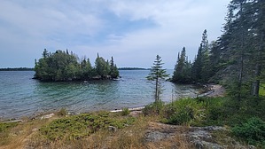
Rocking the Harbor by The_Eagle The trail starts close to the Visitor Center, where you’ll begin your hike through lush forests and rocky terrain. As you hike, you'll see a variety of trees like balsam fir, white spruce, and paper birch. You may see wildlife, such as moose, red foxes, and snowshoe hares. You might also spot eagles or hear the calls of loons from the nearby lakes.
As you make your way towards Moskey Basin, you’ll come across the remnants of the island’s history. Isle Royale was used by fur traders and loggers in the past. The area around Moskey Basin was once an important spot for these early settlers, and you can still see signs of their old campsites and trails. There are camping opportunities on either end of the trail, as well as at Three Mile Campground and Dairy Farm Campground along the way. Once you reach Moskey Basin Campground, you’ll be rewarded with beautiful views of the lake and a great place to rest. The Rock Harbor Trail is a fantastic way to experience the natural beauty and rich history of Isle Royale. Check out the Official Route and Triplogs. Leave No Trace and +Add a Triplog after your hike to support this local community. One-Way Notice This hike is listed as One-Way. When hiking several trails on a single "hike", log it with a generic name that describes the hike. Then link the trails traveled, check out the example. | ||||||||||||||||||||||||||||||||||||||||||||||||||||||||||||||||||||||||||||||


